Hi All~
The
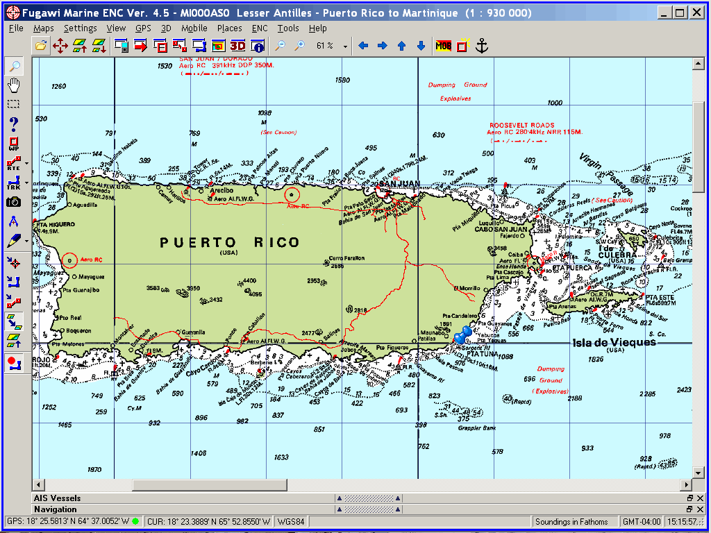
crew of Windigo spent Hurricane Season 2009 in Puerto Rico.
We thought it would
be a great place to spend the hurricane season because of many protected
anchorages; It turns out to be a fabulous cruising ground, with interesting
sights ashore and fabulous Hispanic people across the land:
http://ciekurzis.org/Circumnavigation%20of%20Puerto%20Rico/Circumnavigation%20of%20Puerto%20Rico.htm
And now, the
eLetter:
Circumnavigation
of Puerto Rico
Hurricane
Protection.
After
the 10,000-mile USA Tour, we returned to Windigo which had been floating
off Christensted in St. Croix under the watchful eyes of Dan & Kimber
Lundgren. We decided to spend hurricane season around Puerto Rico because of
the outstanding security afforded by the anchorages along la costa meridional
(the southern coast) in the event of a tropical storm. With the season upon us,
and eager to embark on another adventure [before the necessity of returning to
work], we sailed through the BVIs and commenced a very thorough exploration of
Puerto Rico.
Previously,
during a long stay in San Juan, I published an informative eLetter about the
political development and standing of Puerto Rico
<http://www.ciekurzis.org/PR/PR.htm>. This eLetter will also include
historical and geopolitical facts, but will mostly be the recounting of the
highlights of the visits to each anchorage (all sixty-three of them!) and the
tales of our encounters with the place and its [completely wonderful and
attractive] peoples.
Most
of Puerto Rico.
The
way I describe it is thus:
San
Juan is an American city of two million people (largest of any on a Caribbean
island) living and working spread out across the costa septentrional de (north
coast of) the third-largest, hilly Caribbean Island. It is a major port, with
abundant shopping and services just as all Americans enjoy everywhere. There is
a Spanish flavor to it, especially to the area of Five-Hundred-year-old
buildings and culture that is physically present on Viejo San Juan (Old San
Juan). Turistas flow in & out of the city, mostly conveyed by the giant
cruise ships docking off Viejo San Juan, or through the very busy Luis Muñoz
Marín International Airport.
The
rest of Puerto Rico consists of vast coastal and mountainous regions of every
type. There are rocky cliffs, long stretches of sand, and coral reefs; there
are arid desert areas, rain forests and everything in between. Lakes, rivers
and streams cover the island. Away from San Juan, it is a truly Hispanic
country, with EVERYONE speaking Espanol, most young people are at least
bilingual, and many other folks are competent in English. There are less
immigrants here than on other Caribbean islands; the residents have deep family
values; most are active in the community and interested in government; and a
large percentage are well- educated and display more common sense than I find
in the States. A truly engaging place.
[NOTE: I cannot help myself injecting
Espanol into this eLetter; we became slightly proficient at speaking and
understanding the language whilst in Puerto Rico (Hispanic natives were
correcting my PRONUNCIATION- do you know how pleased I was at even KNOWING
Spanish words??). Now back in the English-speaking world we do not enjoy
exercising our new-found feeble vocabulary. I will try to remember to define
any unobvious words.]
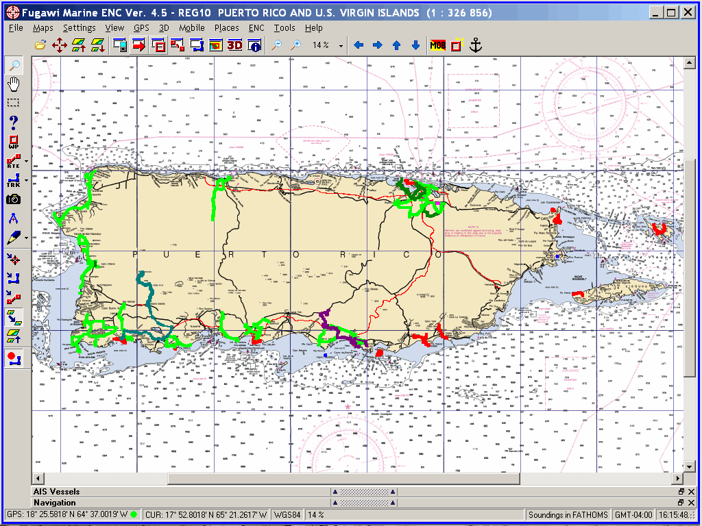
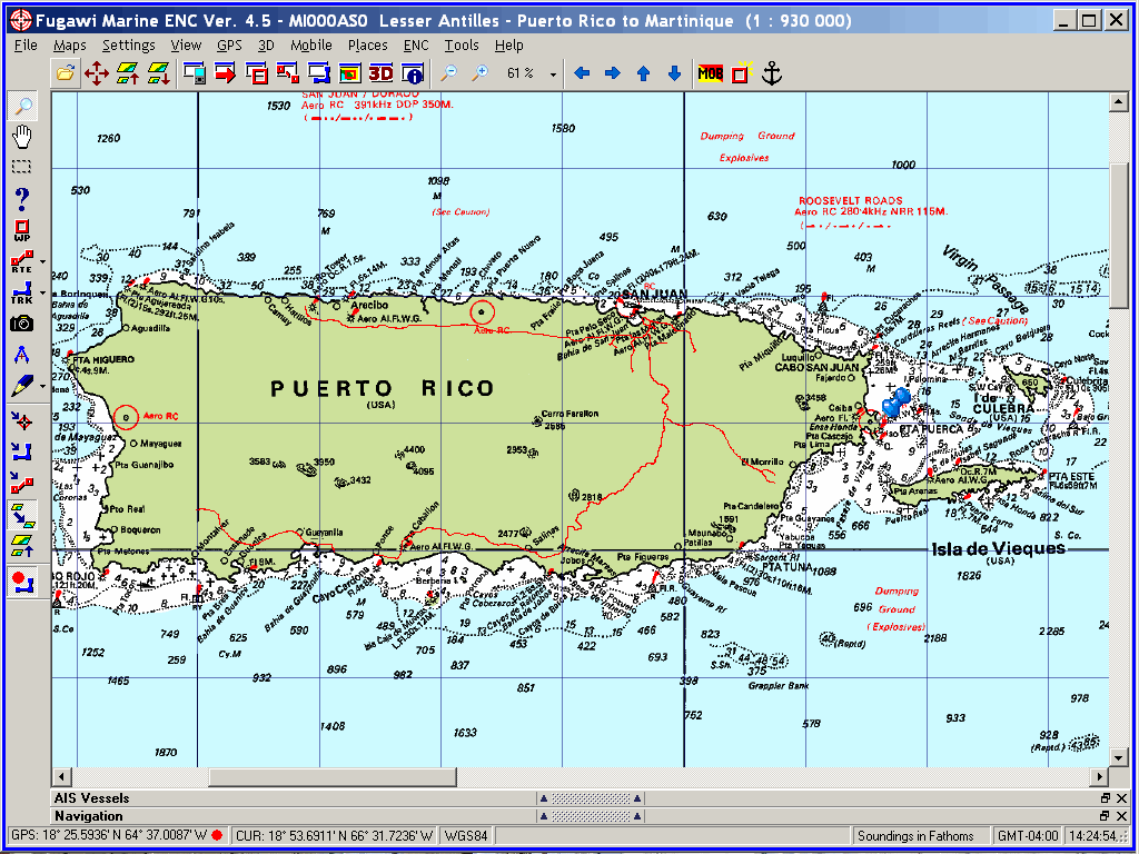
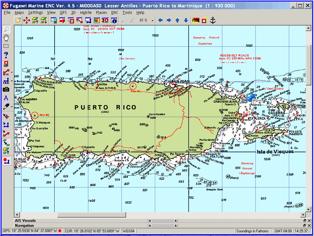
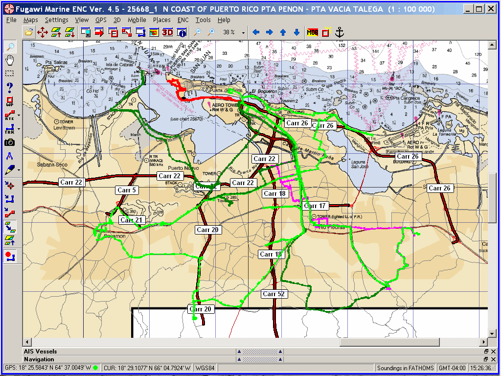
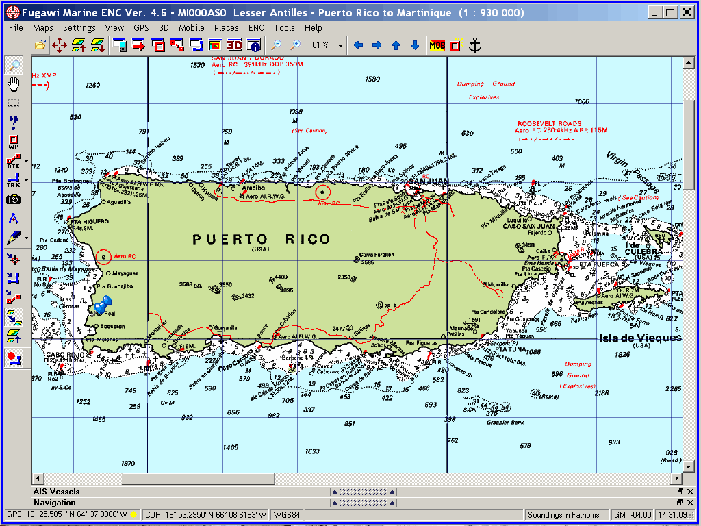
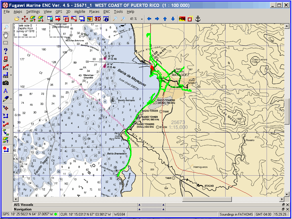
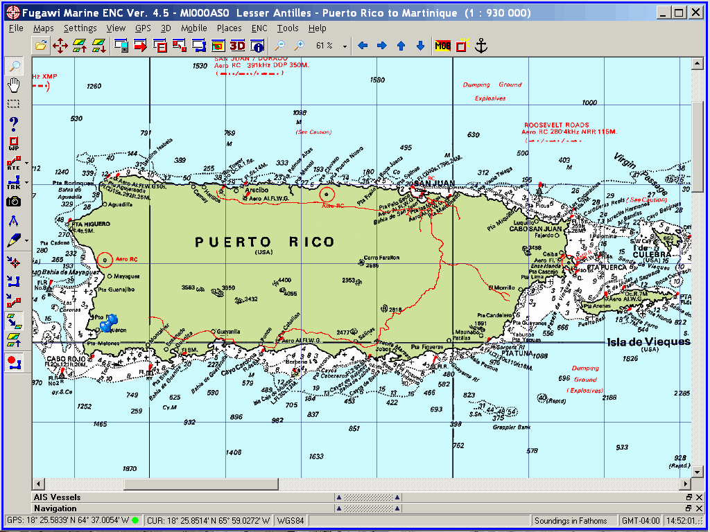
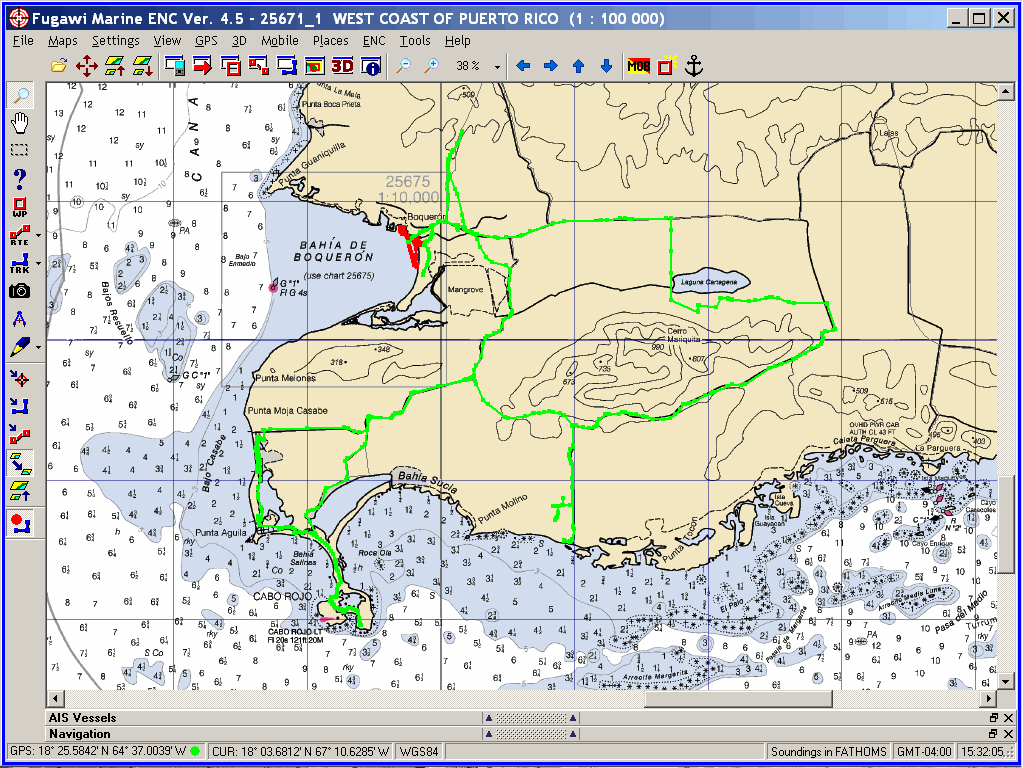
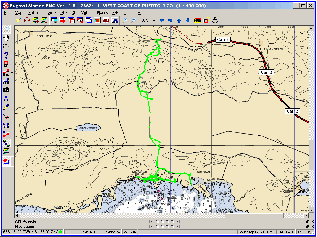
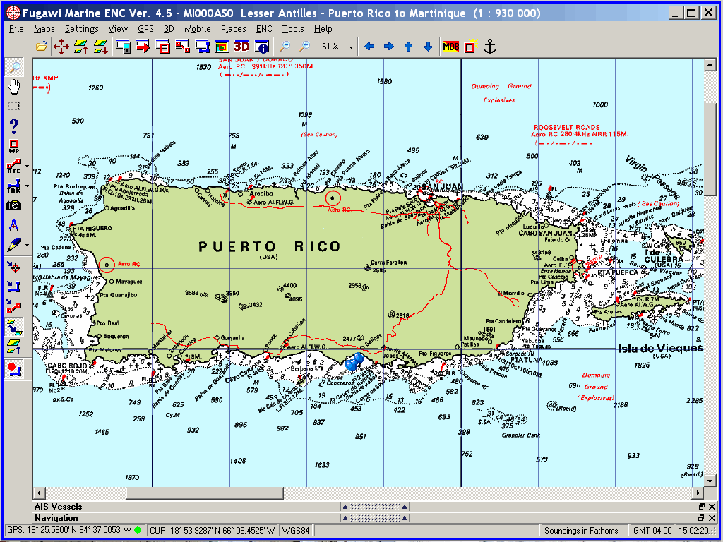
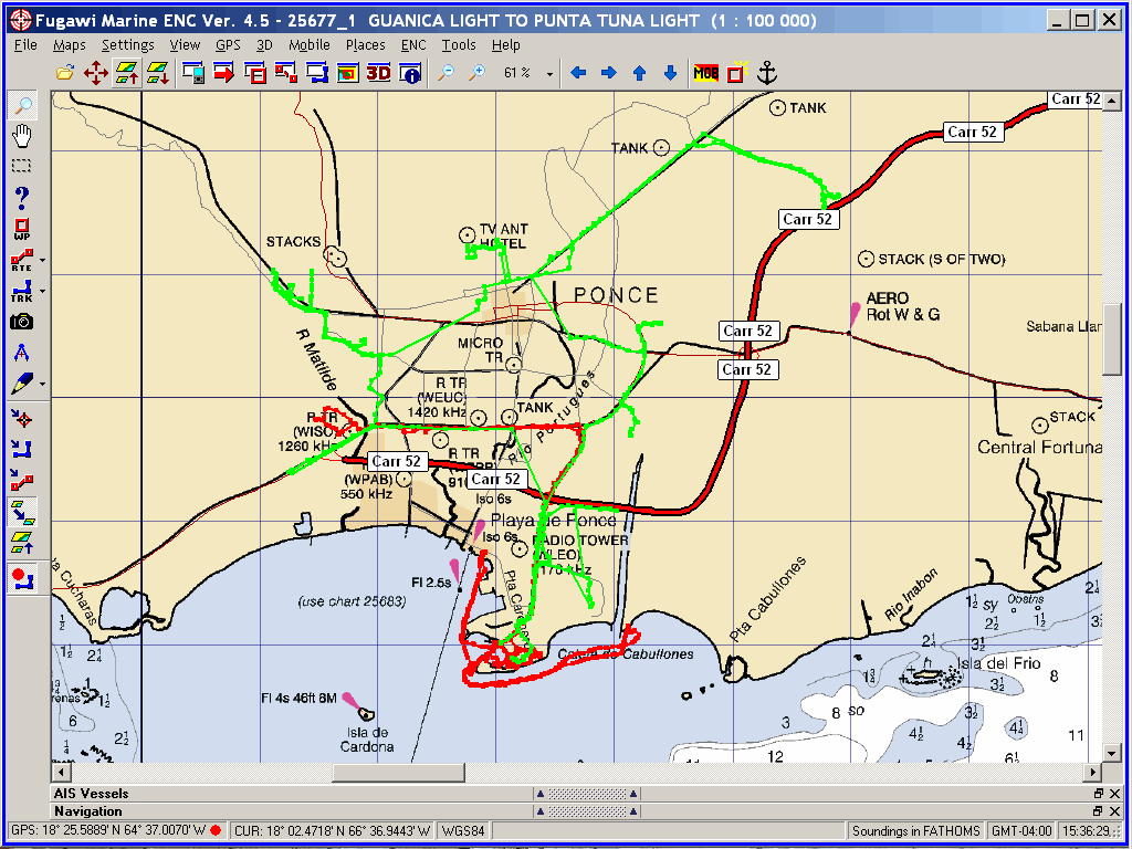
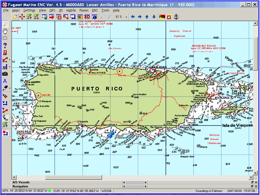
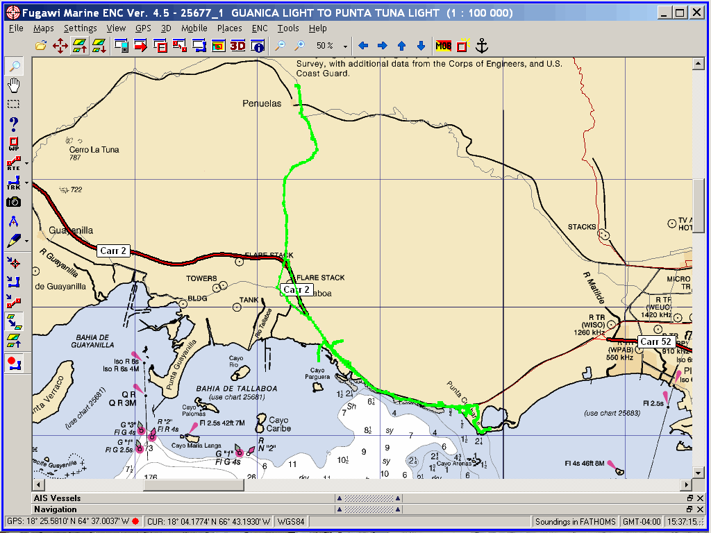
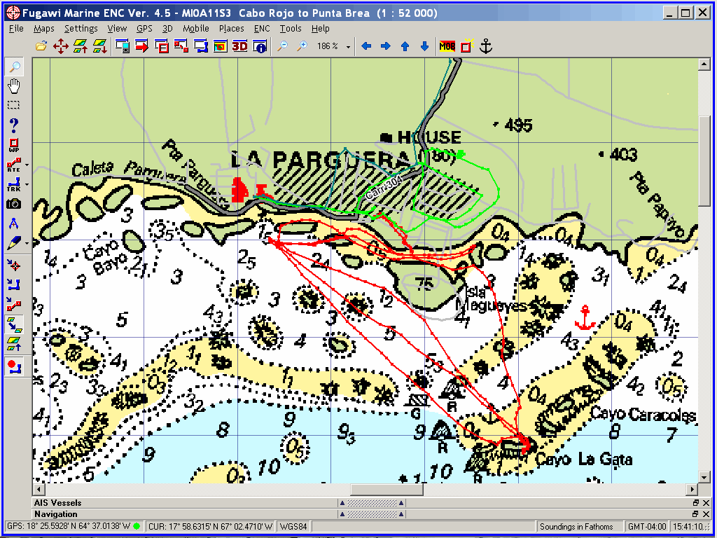
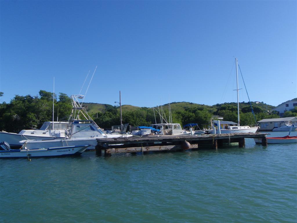
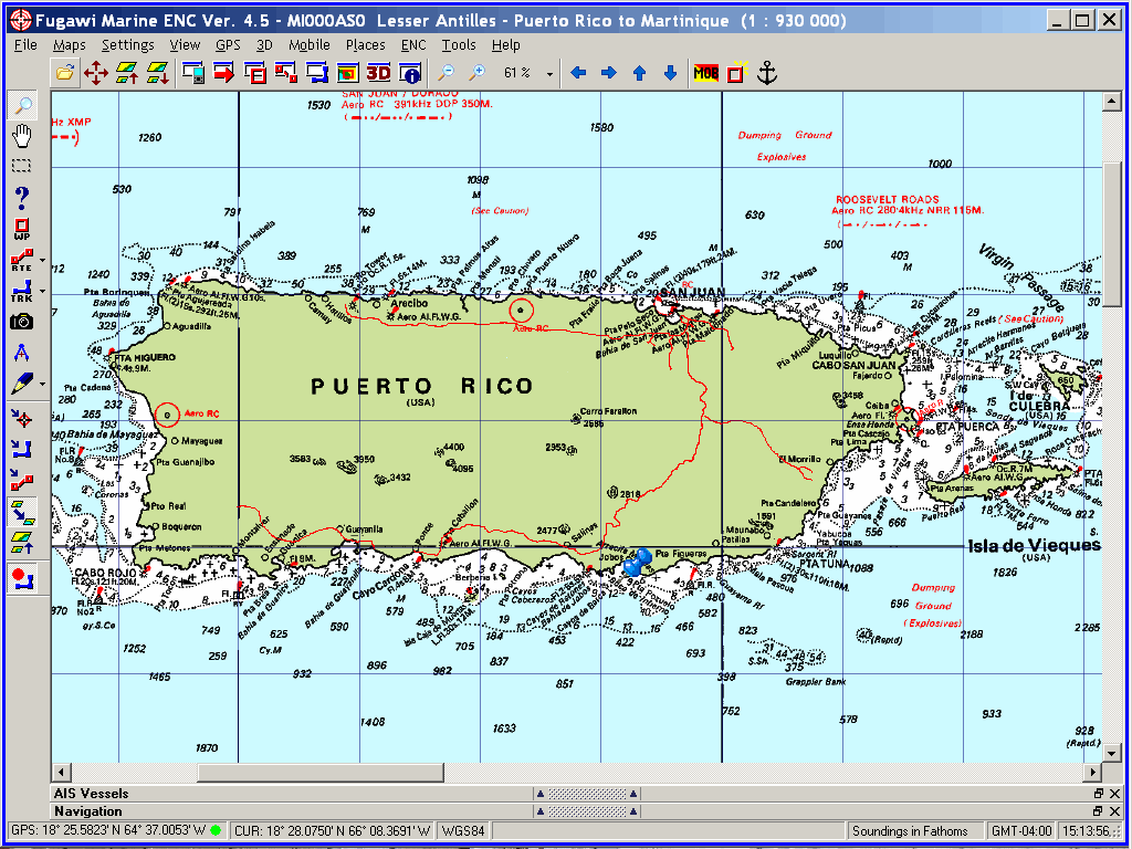
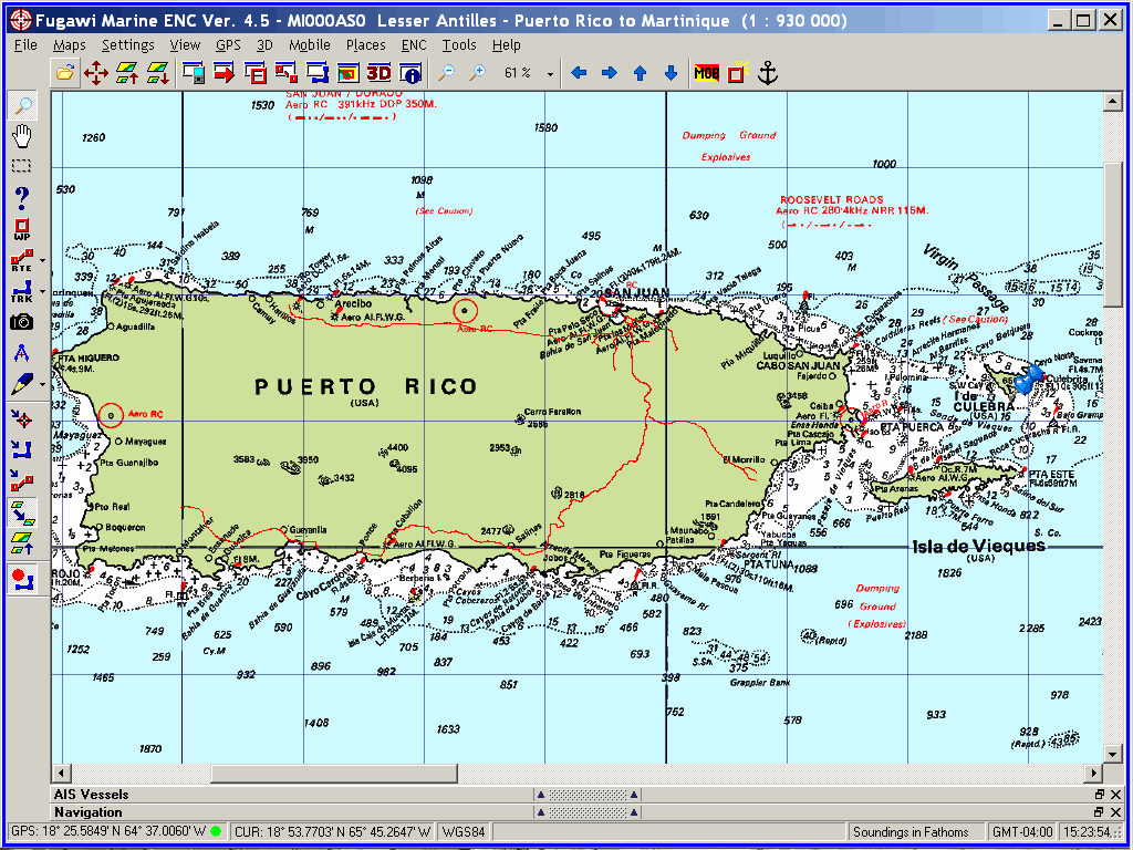
As you
can see from the map, we moored and anchored in almost every conceivable nook
and cranny around the islands. We had opportunities to explore inland
on several occasions, and learned from locals what was in the areas we did
not access during this voyage. We acquired a tremendously thorough knowledge of
the country, but intend on spending much more time there in the future to
explore the areas we missed and indulge in the culture, language and
hospitality of this magnificent place.
[BLUE
tracks are where Windigo went; RED shows the Pedigo track; GREEN
includes cycling and hiking trips.]
True to the name of this
on-line diary (which I will now observe, predated most "weblogs" or
"blogs" on the inet, just as the KL Empire website [now lost]
predated most personal websites in 1991) this eLetter describes each place we
stopped around Puerto Rico.
The exact coordinates of the anchorage and a
short description will begin each entry for interested cruisers.
A short geological/geographical/geocaching
;-] description will then lead into our activities and observations of the
area, and of course the interaction we had with the peoples there.
All these places have Hispanic
names. Duh, it's a Hispanic country! So I need to have you all pronouncing
these places correctly if you ever have hopes of visiting. It is so easy: even
I, the former butcher of French, German, Spanish, and a few other common languages
have begun to correctly pronounce this stuff.
The VOWELS are ALWAYS
pronounced the SAME WAY! Very cool. They are NEVER silent, so they always
create another syllable. Every vowel deserves pronunciation, but not too much
emphasis;
keep it short & sweet.
A= ah, as in cart & yard.
E= eh, as in egg.
I= ee, as in the name 'Ian' & the
vowel sound in 'me'.
O= oh, very short, as in obey &
zero.
U= oo, as in guru & the vowel
sound in 'choose'.
Another easy thing to do is
watch the accents and obey them. [It's not rIN-con, but rin-cOn because of the
accent over the "o": Rincón.] Without the accents, put the stress on
the NEXT-TO-LAST syllable for all words ending in a,e,i,o,u,n & s; all
other words have the stress on the LAST syllable.
I make speaking a foreign language FUN!
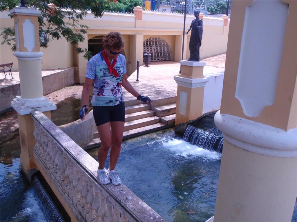
After sailing sixty miles, we
decided to moor in a really serene, isolated spot to enjoy nature.
This was the first of many time we used the
moorings placed and maintained by the Departamento De Recursos Naturales Y
Ambientales (Department Of Environmental & Natural Resources) or DRNA. These mooring balls can be
found all across the National Park and Beach areas of the Spanish Virgin
Islands on el este de (the east end of) Puerto Rico; they are provided
free-of-charge, with no restrictions of over-night use or length of stay, other
than your consideration for others to use them in periods of great activity.
[NOTE: This mooring
service is unique and special compared with anywhere I have seen or heard of in
the world. In the BVI moorings are provided in several harbours and are free
during the day, but cost $25, $35 or $65 for overnight use.
The moorings of the BVI National Parks
Trust number over 200 and are placed in sensitive areas where anchoring is
not allowed. There use requires a Park Permit obtained for a one-time small
fee, have a 90-minute time limit with no over-night stays permitted.
The US Virgin Islands have
mooring balls in the National Park areas (whether sensitive or not) and charge
$10 or $15 for each day's use. IF all the moorings are full, you are allowed to
anchor, but they will still charge you! American bureaucracy overrules
international law and common sense?]
The tiny Isla Culebrita off the
costa de Isla de Culebra in the islands al este de (to the east of), and part
of, Puerto Rico.
Being a Sunday, there were 14 power boats on
the beach of this popular daysail and picnic spot. Locals from the main island
(historically known as Borinquen) make the short trip to this
idyllic island to laugh and play at the edge of civilization.
Isla Culebrita is one of 23 islands around
Isla de Culebra that make up the Culebra Refugio Nacional de Fauna (Culebra
National Wildlife Refuge), perhaps the oldest refuge under the auspices of the
US Fishing and Wildlife Service.
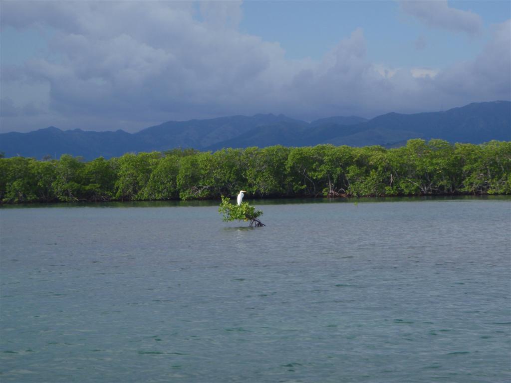
A unique tidal pool, locally
known as the Jacuzzis, provided an afternoon
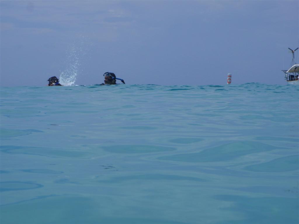
of exploration for us. We snorkeled the crystal clear water and hiked the
jagged rocks. Later, we sat in the tidal pool that is flushed by ocean waves
breaking on the outer shore.
The protected harbour provided
a most peaceful sleep and a tranquil introduction into the cruising wonderland
known as Puerto Rico.
A twenty-five mile sail across
Sonda de Vieques to la costa meridional de (the southern coast of) Isla de
Vieques brought us to this large, formally restricted harbour. We anchored in
the deepest, most remote recesses in el este de (the eastern end).
Since the US Navy's live firing
range has been forced off this beautiful island, the military continues to
clean up the hazardous waste deposited here over decades of misuse.
We actually radioed the USCG and broke one
of our primary 'rules' (NEVER ask for permission; It is easier to beg
forgiveness) and inquired about anchoring here. Humorously, the Coasties were
confused by one of the most prominently goofy features of island toponymy = there are so many places with
the same name across the islands, even on neighboring islands, and even on the
SAME island! So when I asked about entering Ensenada Honda, they assumed I
meant Ensenada Honda on Borinquen, even though I specified Isla de
Vieques. So they proceeded with a detailed description of how to enter, where
to navigate, how to anchor, and what restrictions there are in Ensenada Honda on the main island adjacent to
Roosevelt Roads Naval Base. So helpful ;-] We thanked them and worked our way
into the depths of Ensenada Honda, Isla de Vieques with renewed
encouragement to NEVER ASK FOR PERMISSION.
When the US Navy abandoned
there holdings on Isla de Vieques, they took everything with them
(unlike the abandonment
of the bases in The Bahamas). It
was surreal to sail into a huge, unmarked bay; and anchor all alone in one of
the most incredibly beautiful natural areas of the United States. Although development
is occurring is isolated spots on the island to support the few inhabitants,
most of the formerly federal government land has been set aside for parks and
preserves. A good start for making up for years of exploitation and abuse of
this magnificent island.
(There are many other bays of
Vieques now accessible because of the cessation of the major Navy activity
here; each and every one of them MUST be explored to the limits of our
abilities during our next visit.)
*I want to come clean
right away: THEY told me there are no exceptions to the vowel rule in Espanol,
but Vieques is pronounced "vee-A-cuss"; as "que" all alone
(meaning "what" or "that") is a very short -k- sound.
Seeing
we already had 'permission', we headed over to Ensenada Honda on Borinquen. They do
require every cruising vessel to radio "Roosevelt Roads Naval Base" for
permission and instructions, but are not too austere in their enforcement of
that rule. We anchored on a hump just outside a group of mooring balls off the
marina in el norteoeste (el northwest) corner of the bahía. (Kevin's Trivia:
This had been the world's largest Navy base when it was active. The only larger
military base is Davis-Monthan Air Force Base, where I was stationed in
Arizona, the location of the aircraft storage depot.)
As going ashore is slightly restricted because
of the Naval Base, we took advantage of the quiet anchorage to accomplish a few
boat projects such as the never-ending chore of protecting the wood exposed to
the elements.
After yet another completely peaceful night, we
weighed anchor only to have the wheel steering fail within a few minutes of
getting underway. It seems that the life expectancy of the chain linkage of Windigo's
helm is 42 years as one link parted leaving us to steer first with the sails
and eventually with the emergency tiller. A US Navy boat with a couple of
sailors aboard came by as we were reanchoring after noticing we were having
problems. It is so great to be in a place where although Big Brother is
watching, he isn't there to hassle you, just to help. How cool is that?
After securing Windigo and thanking the
DOD Security seamen, I rummaged through the spare parts and came up with enough
chain links to repair the steering system. We left once everything was again
fully functional and restowed into the bowels of the boat.
Our
anchorage here is not in any type of harbour, but an open-water shallow spot I
found last year on el oeste (the west) side of Isla Piñeros, al norte (near the
north) end, in Pasaje Medio Mundo (Passage of Half a World - which probably got
its name from the explorers that traveled great distances to get there!).
A
completely calm and serene locale, I 'discovered' it while single-handing along
el este de (eastern) Puerto Rican shore in unsettled weather. As a huge squall
rolled across Sonda de Vieques, I slipped in the Pasaje Medio Mundo just before
winds exceeding 40 knots swept through the area. Although I was spun in circles
(literally) in the narrow channel, the seas remained calm and I was able to
emerge above Punta Puerca fifteen minutes later.
This
time, no threatening weather ensued, and we enjoyed hours of snorkeling in the steady
current flushing through the passage. The highlight of this remote stop was the
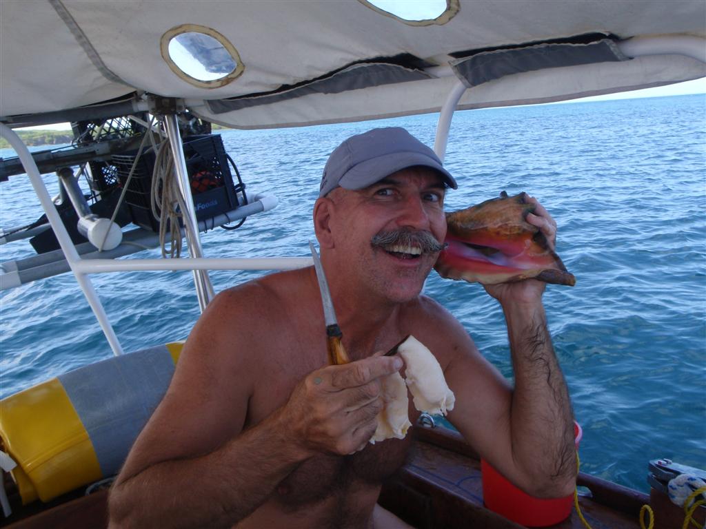
retrieval of a half-dozen conch whose meat provided first a conch strip-steak
supper, and later a conch salad lunch. Delicioso!
Another
incredibly beautiful island with FREE DRNA moorings!
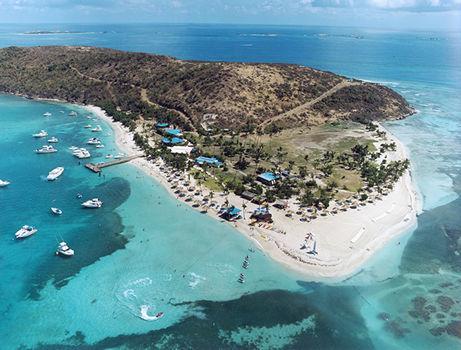
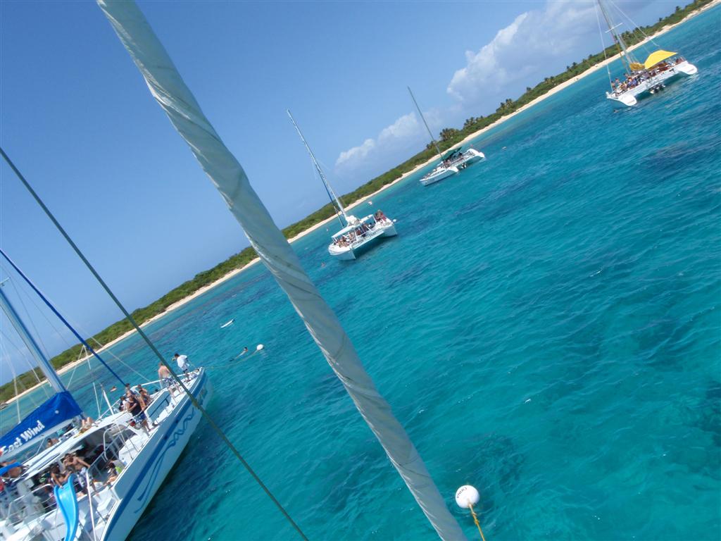
The El
Conquistador Resort & Golden Door Spa has an exclusive lease on Isla
Palominos, and has extensive
development on la costa meridional de (the southern coast of) the island.
But there are almost two dozen moorings off el norteoeste (the northwest) shore
just under a magnificent reef. Besides the occasional cruising boat, these
moorings are used daily by charter companies that bring throngs of turistas y
personas indígena alike for a few hours of frolicking in the warm Caribbean
water [and free drinks!].
We swam over the reef during a quiet time and
retreated back to Windigo when the giant catamarans arrived with their
landlubber guests. The people-watching was great!
An
easy voyage of a little more than five miles al norte (to the north) and oeste
(west) brought us to Cayo Icacos, between Las Cucarachas and Cayo Lobos and
part of the Reserva
Natural La Cordillera. Actually, Isla Palominos is part of this Nature
Reserve, but Cayo Icacos is in-line with the string of islands that are
obliviously "The Mountain Range". Besides the ones mentioned, the
other colorfully-named islands include:
Los Farallones,
Cayo Ratones, Cayo Diablo
and la Banquilla, Arrecifes Hermanos, Arrecifes Barriles, and Isla Palominitos.
[With names of "rats" & "cockroaches";
"devils" & "barrels"; "brothers" & little
horses", you know these are cool islands!]
Being
managed by the Departamento De Recursos Naturales Y Ambientales, there are
several mooring balls there conveniently placed next to ANOTHER incredible reef
and snorkeling paradise. Similar to Isla Palominos (in fact, one could mistake
one for the other), the day charters come
over to enjoy the submarine ecosystem and it is a 'must see' stop for
cruisers.
This
well-protected anchorage provided us with the ideal launching point for the
35-mile downwind trip to Bahía San Juan and our old stomping grounds of
Santurce & San Juan.
I
described this area pretty well in the first Puerto Rican eLetter, and
everything is pretty much the same. Lots of construction and crazy traffic
abound. But returning to our friends here was terrific; Bill Butler was holding
our mail, and we dined with Lillio & Bill and had a delightful time. Jorge,
Judi, Maritza and Hector were around; and we met a few new people including
Elsa, at the San
Juan Community Library at Bucaplaa, whose son Fernando has a boat in
Salinas- we would meet up with him later in the voyage. We were able to see our
friend Peter off to hospital for heart surgery, and hung around to cheer him up
when he got discharged. He was pretty beat-up by the whole affair, but came out
better than ever.
We geocached here in
earnest and scored many new caches,
including one that I worked at SO MANY TIMES in previous visits (I FINALLY GOT
YOU, COFFEE
BREAK!!). I also made a Sunday visit to El Morro
to fly my kite. We connected with some old geocaching friends when they noticed
"WindigoIII" showing up on the cache logs once again. They had no
idea how much of us they would get to see later . . .
We accomplished many, many boat projects (we
LOVE West Marine) including major upgrades to water systems, waste systems,
canvas assemblies, Pedigo, external wood, and the installation of a new
super-duper WiFi antenna system that has enabled us to receive inet aboard Windigo
in most developed harbours. WooHoo!
With the mail received and aboard, and with the
arrival of fairly stable weather, we headed out into the unknown (to us) and
unexplored (by us) waters al oeste (to the west) along la costa septentrional
(the north coast). We were actually cruisers again!
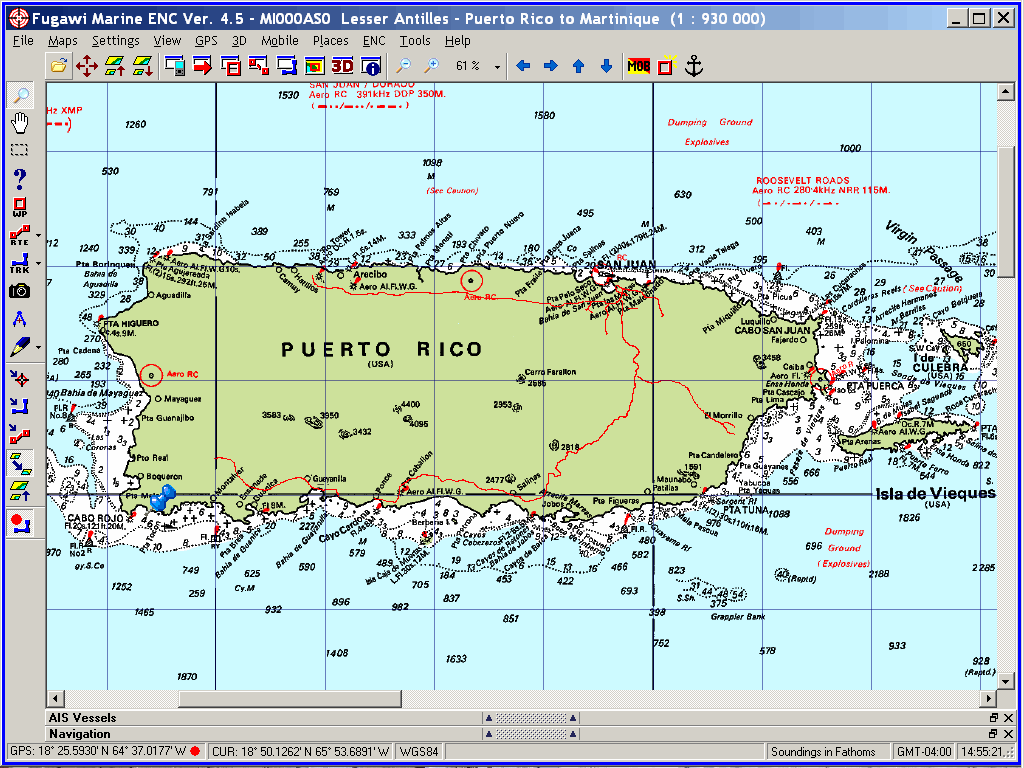
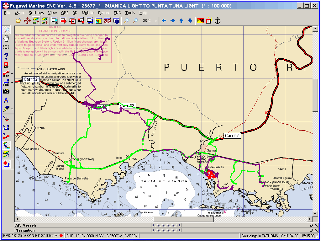
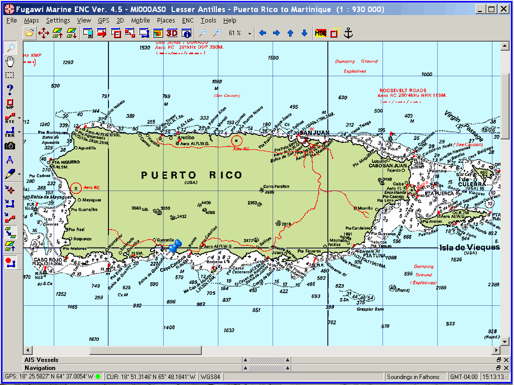
Arecibo, PR - N18° 28.733' W066°
42.149'
There
are not too many places to anchor along la costa septentrional de (the north
coast of) Puerto Rico with a small sailboat, even in the calmest of weather. We
had 20 to 30 knots of wind and 3-meter seas on the first leg of our anti-clockwise
tour of Borinquen; so there were a couple attempts made to poke into
various reefs and notches in la costa, but the only safe landing we could make
was at Arecibo, a 37-mile trip oeste (west) from San Juan.
Although not noted in any cruising guide I have
seen, a calm anchorage can be had if one tucks behind the jetty in el este de
(the east end of) the harbour, just behind the century-old functioning
lighthouse at Punta Morrillos.
Arecibo has the distinction of encompassing the
largest land area of any Puerto Rican municipality. It is also one of the
oldest ciudads (cities), existing for over 500 years (formally 'founded' in
1515). Along with the restaurant, beach and museum at the lighthouse, the
ciudad itself is interesting and attractive.
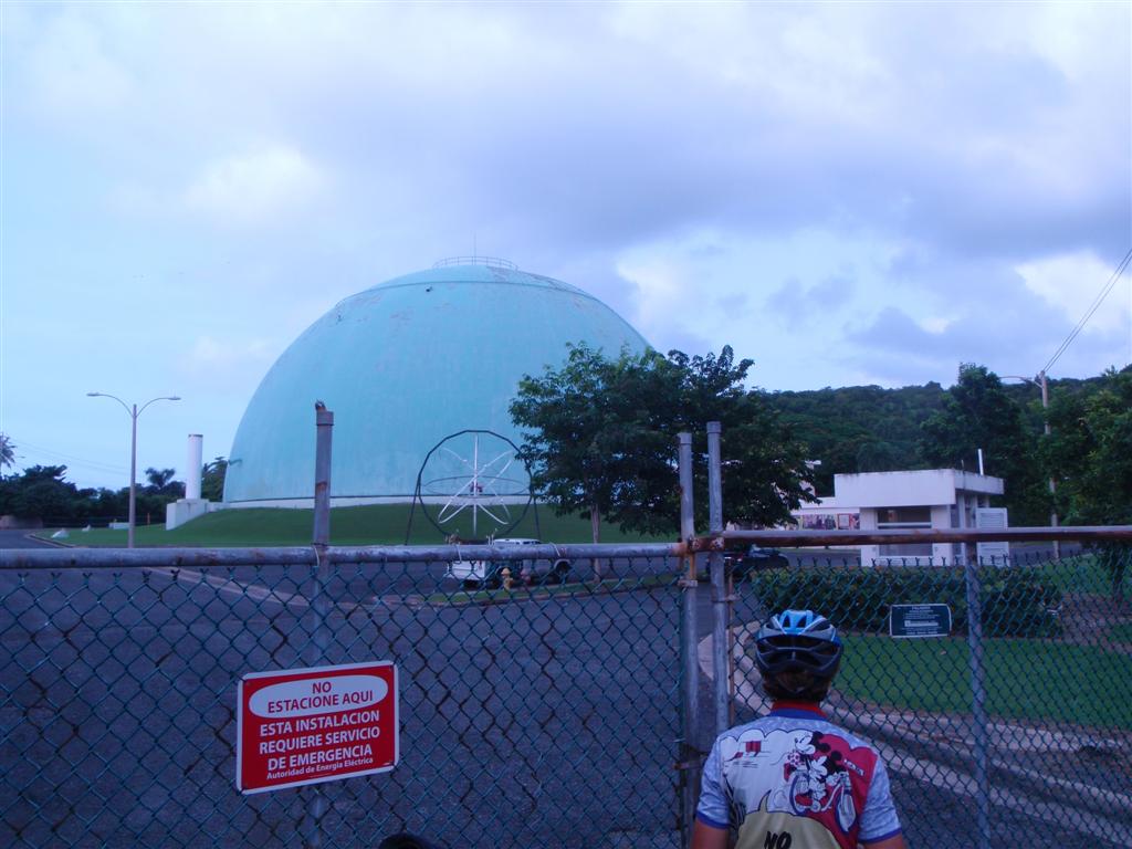
We were finishing up a few loose ends on the
projects begun in San Juan when I checked the weather. It seemed that Tropical
Storm Ana was trying in fits and starts to become significant and come to
Puerto Rico. Well, that's why we were here! Except la costa septentrional (the
north coast) is no place to be for a hurricane! We had to pack up and
skeedaddle the next morning. So at 1400hrs. I made the announcement to my crew,
thinking she would freak out a bit and rush us around to a hurricane hole.
Instead she says, "If you're gonna ride your bike up to the world's largest radio
telescope like you have been blabbing about for months and months, you'd
better get going!"
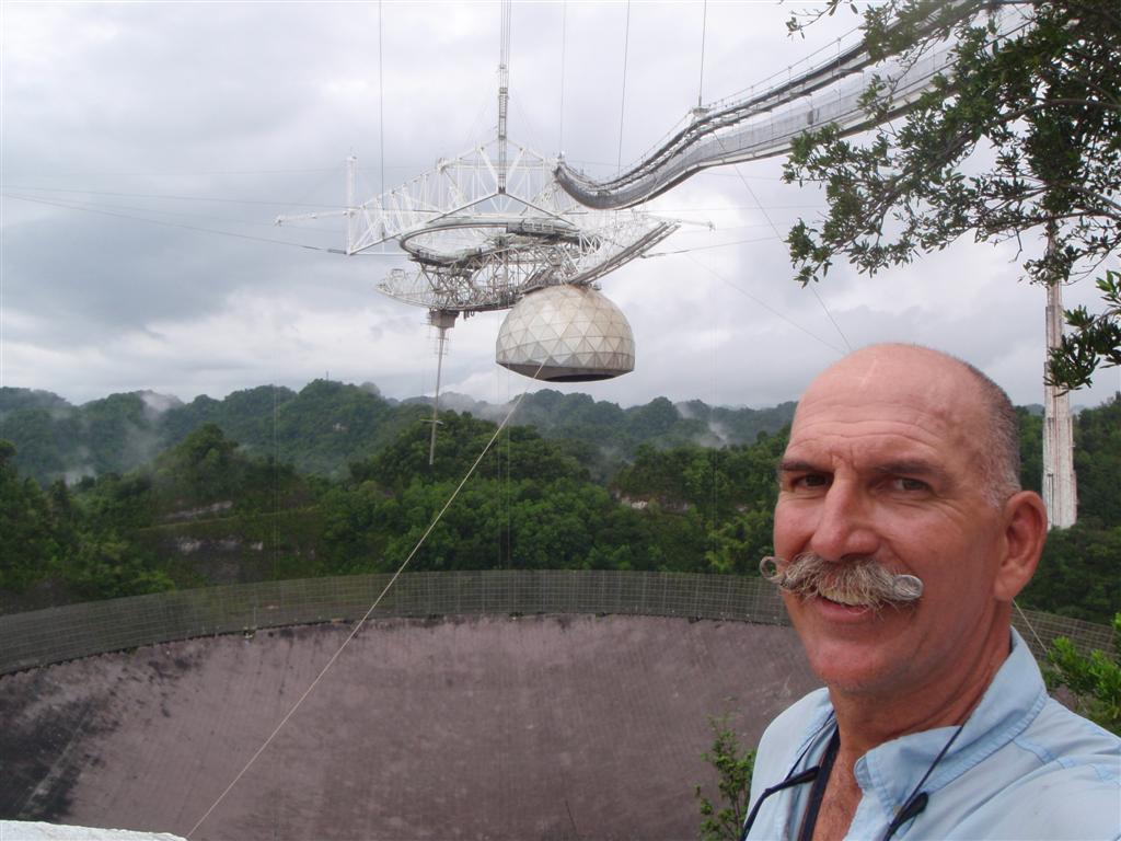
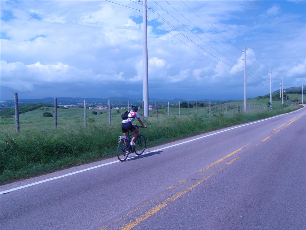
My plan was for the two of us to leisurely
cycle to the Arecibo Observatory in the morning; but now it wasn't prudent to
stay even one more day. So in the matter of fifteen minutes, I was standing on
the shore with my bike in hand dressed for peddling. Karin was NOT going to be
rushed into humping up a 1200' mountain to see some science project that
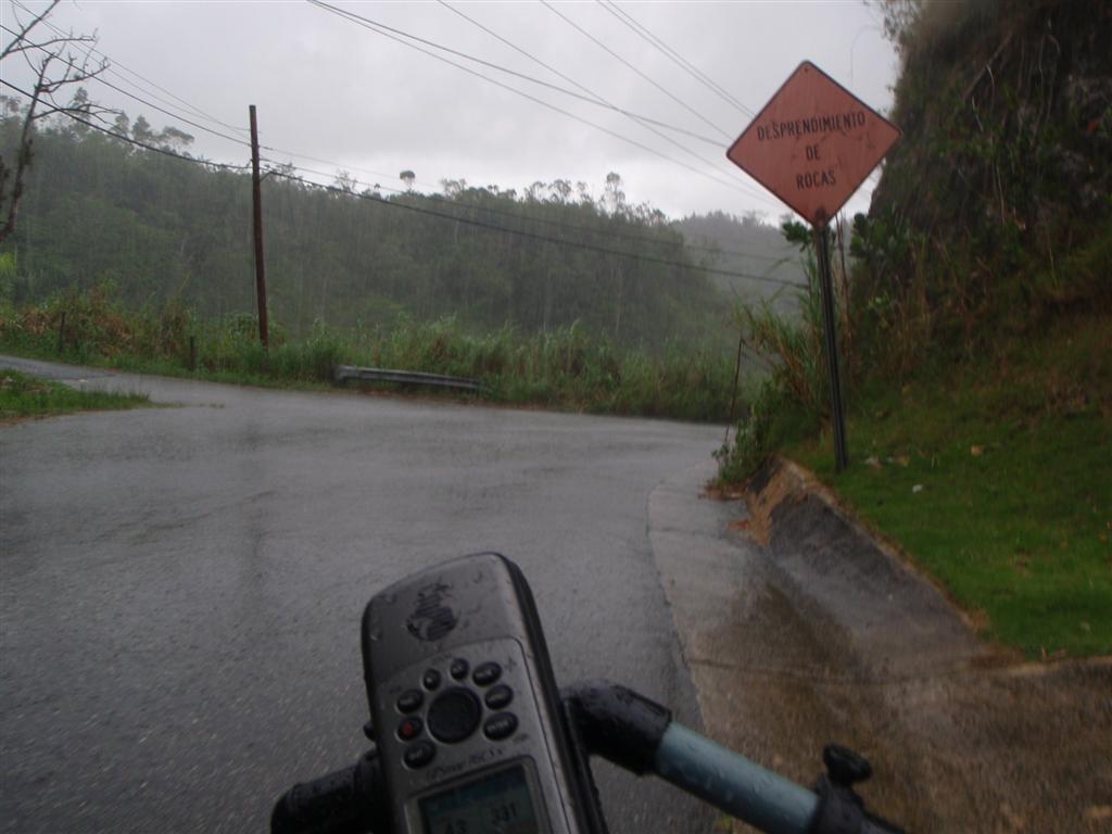
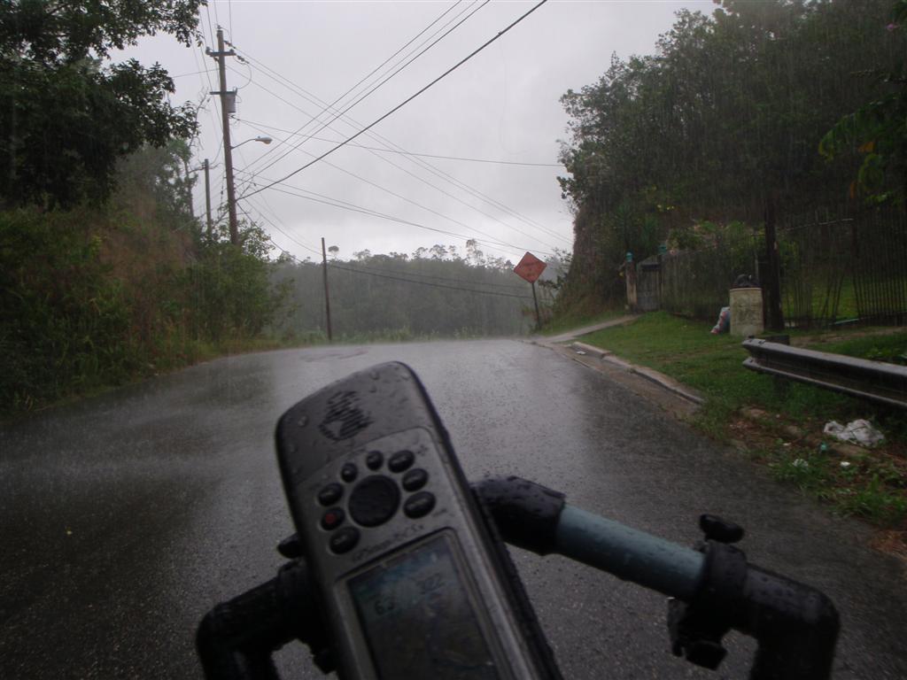
thrills me. I would say the ride up was slightly more than thrilling. The twelve-mile ride up took about
two-and-a-half hours. (The descent lasted
only a half-hour!)
But it was worth it; Besides getting to see something I admired in my childhood, and
remembering the details of its construction at the time it was built, I nabbed
a really great geocache! The refreshing rain shower during the descent didn't
bother the handling of the Dream Police Ti (my new bike) as the hydraulic
brakes and cool NY Bike Messenger tires handled
the wet, fast pace with ease.
Upon returning to Windigo, we prepped
for an early morning departure to head around el norteoeste (the northwest)
corner of Borinquen.
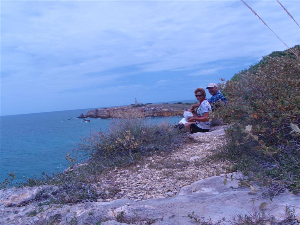
Rincón, PR - N18° 20.500' W067°
15.503'
I had
chosen Puerto Real el sur de (the southern) extremity of la costa occidental
(the west coast) for the best protection from Ana, should it become a threat
and head this way. But it was too far to reach in a single day.
With
plenty of time to get to Puerto Real, we stopped for the night off Rincón, a
40-mile trip from Arecibo. Checking the weather, swells, geocaches, water
depth, and shore access, we vowed to return here later for an extended stay to
explore the shore. Stay tuned . . .
We
made it into this completely protected anchorage and delightful fishing
village, only a 20-mile sail down from Rincón. The entrance to the bahía looks
tricky on the charts, but we made our arrival straight down the middle, and our
exit more conventionally nearer to el sur de (south side of) the entrance. Then
we found sailing inside quite easy even with our seven-foot draft, anchoring as
close as we could to the town and the fishing boats.
With
no geocaches right in town, and finding ourselves unprepared* deep within the
"Hispanic" reaches of the country quite early because of the storm, we
did not venture to shore, but only waited the day that was necessary for Ana to
dissipate. We vowed to return here during a future voyage and explore this town
more thoroughly.
[*no practicado en
nuestro Espanol!]
Joyuda, PR - N18° 07.027' W067°
11.081'
With
the weather now calmed by the deceased storm, and over three-dozen geocaches
right along la costa occidental de (the west coast of) Puerto Rico, we began
poking our way al norte (to the north). The first stop was nestled in between
Cayo Ratones and the pueblo of Joyuda ["J"s are pronounced like a
hard "H"; "H"s are always silent*!].
*For you advanced students, the
"H" may NOT be silent when it is NOT the first letter of a word or
when it is NOT between two vowel sounds, which is rare. But "H"s are
not necessary, as the "J" has the hard "H" sound!
The
shallows really close to the shore are fairly calm, and Joyuda is a friendly
little pueblo. The water is actually extremely attractive for swimming and
snorkeling. There is also a row of seafood restaurants that is known as
"Milla de Oro del Buen Comer" (The Gourmet Golden Mile) that offer
affordable, fresh fish.
We
tackled the multi-stage geocache which began here in town, but required us to
get out to Cayo Ratones. We had to relocate Windigo closer to Cayo
Ratones as the daily free ferry provided by the DRNA was still put away because
of Tropical Storm Ana and we had to swim to the island if we wanted to find the
cache. Such is the life of the sailing-geocachers . . .
So we
moved Windigo the 1300 feet over to Cayo Ratones, but had to sail over
7000 feet at a snail's pace to get there! Such is the life of the cheapskate
sailor. But now we were anchored in the lee of the island and the water's still
very calm and we can snorkel over to get the geocache. Very cool little island
= just one big picnic area with super nice snorkeling over the rocky bottom.
Nice improvements by the government to make these places very hospitable.
We were back to the boat by noon for lunch, and
then we weighed anchor and headed off al norte (to the north) to check out the
anchorages in Mayagüez.
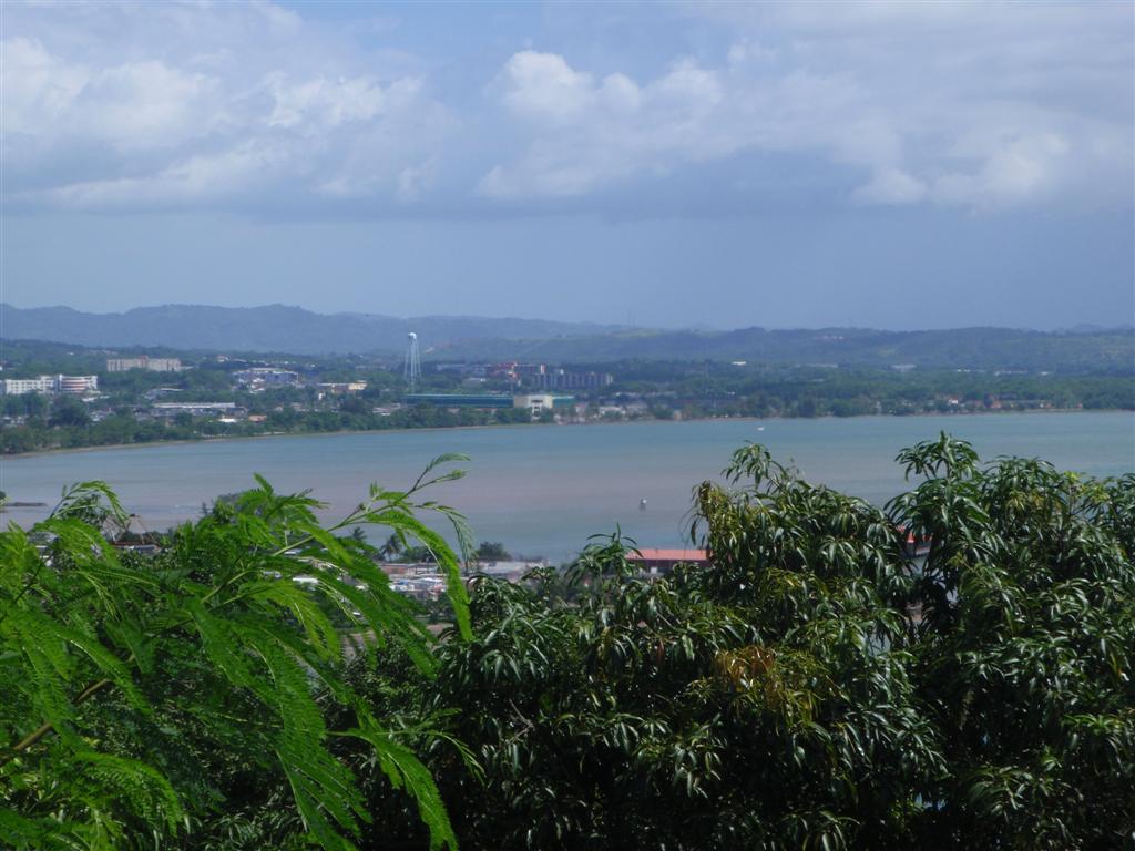
Mayagüez, PR - N18° 11.781' W067°
09.429' & N18° 12.906' W067° 09.575'
The
short sail up to Bahía de Mayagüez was very serene as we stayed inside the
reefs and enjoyed a suroeste (southwest) wind for the trip. The relatively open
Bahía de Mayagüez is
really for big ships, such as the USCG boats that are in & out all the
time, but we found a spot al sur de (to the south of) town, just off the new
construction of some type of stadium that was very nice. Then we moved norte
(north) to just al sur de (to the south of) red buoy #10 of the Mayagüez
Shipping Terminal; be careful of Bajo Mandongo, a shallow reef al sur de (to
the south of) buoys #6, #8 & #10. Windigo easy sailed between the
reef and the shore, but we enjoy navigational challenges.
We
found dockage for Pedigo around Punta Algarrobito at the unused marina
connected to the closed French restaurant on the point; although once Karin
talked her way into the secure area of the docks and I picked her up there - it
was a little crazy, with the HUGE dock structure and fairly large swells,
transferring the bicicleta to Pedigo, but we did it.
The
parking lot of the defunct restaurant had a resident horse with a little colt
that Karin was diligent in feeding daily as we went ashore to explore and
geocache. And geocache we did - we made a quick circuit around town and picked
up the local caches one day, and made the first
50-mile bike ride (of many) along la costa and into the countryside, riding
sur (south) almost to Cayo Ratone and norte (north) almost to Mani.
Being the
third-largest city on Puerto Rico, I found a very cool bike shop in Mayagüez, Ciclo Mundo (Cycle World)
and made friends with the manager, Dolan. [Dolan happens to be the cousin of a
Puerto Rican geocaching Rockstar, Surveyor Alex, one of my acquaintances from
the big geocaching event in 2008 in San Juan.] He and his mechanic fixed two
small nagging problems on the Dream Police Ti and I had to force a decent
payment on them. What a rare find!: competent, inexpensive bike shop employees;
not seen since Wheel & Sprocket in Milwaukee and Tony Piroli in Clearwater.
So we geocached monuments, parks, beaches,
parking lots, zoos, the
University, highway guardrails, historic buildings and defunct bridges
(THAT was a cool one!). We rode our bikes through neighborhoods, parkways,
swamps, and carried them across stretches of flooded beach to save riding an
extra five miles back around salt ponds and rivers. We met locals, immigrants
and turistas and shopped at Kmart and WalMart and I had a chocolate shake at
Burger King, something impossible in the BVI.
A wonderful time was had; we exercised our
vocabulrio, our legs and our minds with all the stimulation. Windigo was
100% and we were ready for the next port of call.
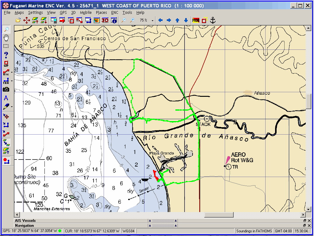
Mani,
PR - N18° 14.902' W067° 10.648'
This
barrio is also known as El Mani; it lies along la costa sur de (the coast south
of) Añasco. We anchored at el norte end of Mani, just sur of Ro Boquilla. With
no type of dock or obvious public beach, we landed Pedigo at the beach
of a construction site; we always engage in the most interesting conversations
with personas indígena while sailing & docking Pedigo,
unloading and load our bicicletas,
trespassing to get to the roads, etc.
From here we cycled
norte past Añasco discovering
geocaches. It wasn't a 50-mile ride, but we were out for a few hours
exploring the area historically famous because of the Taíno rebellion of 1511.
Ponce de León, who accompanied Columbus on his
first trip to Puerto Rico in 1493, was well received by the Cacique (Tribal
chief) Agüeybaná
(The Great Sun), chieftain of the island Taino tribes.
After being named Governor, de León and the conquistadors
forced the Taínos to work in the mines and to build fortifications; many Taínos
died as a result of cruel treatment during their labor.
In 1510, upon Agüeybaná's death, his brother
Agüeybaná II (The Brave) thought that the way his people were treated really
sucked, so he got a group of Taínos to take Diego Salcedo, a Spaniard, to a
river and drowned him, proving to his people that the white men were not gods.
Upon realizing this, Agüeybaná II led his people in the Taíno rebellion of
1511, the first rebellion in the island against the better armed Spanish
forces. The initial Taíno attacks were very successful, but eventually the
rotten conquistador bastards prevailed with their superior firepower and the
Indians were forced into Christianity, slavery and Spanish rule. Such was the
plight of the gentle, peaceful personas indígena of the world as
"civilization"(????) overran them.
This was the
first of many military exchanges in Puerto Rico. The Spaniards successfully
held Puerto Rico continuously for over 400 years, and it only changed hands (to
America) through
a treaty, not an all-out military action.
After seeking all the caches in this area, it
was time to return to Rincón.
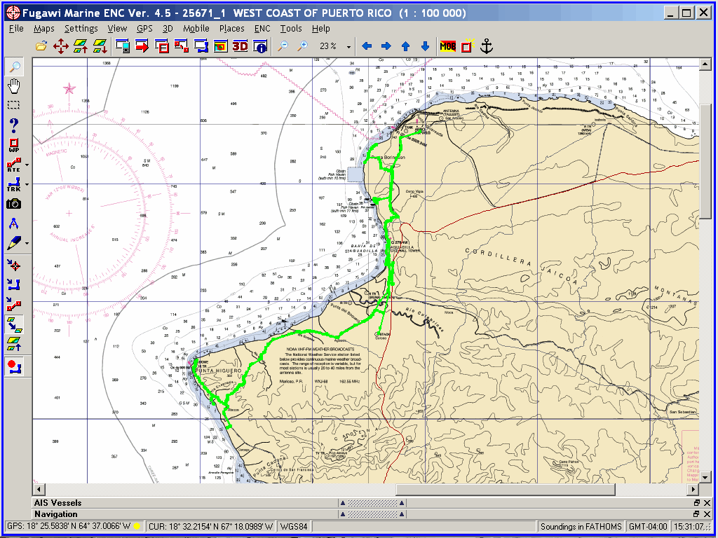
Rincón, PR - N18° 20.500' W067°
15.474'
Once
again anchoring between the beach and the tiny jetty at Punta Ensenada, we
landed Pedigo on the beach behind the jetty and commenced another 50-mile geocaching adventure. We rode
up though Aguadilla, past the airport to
Isabella finding many caches along the way. There are over a dozen along this
costa known for its incredible surfing conditions. We noticed we were sometimes
minutes behind the "Janizy Crew", a group of geocachers from the
Santa Isabel area we would meet the next month at a geocaching event.
After exhausting the caches (and Karin) we
cycled back sur and out to the tip of Punta
Higuero and the popular ruins of the Faro de Rincón (Rincón Lighthouse) and
an old nuclear power
plant. It happened to be the weekend of the Puerto Rican National Mountain
Bike Championships. So after riding through the lighthouse ruins and the
abandoned nuclear power plant, we jumped on the race course and blew through
the finish line - albeit an hour after the race was over.
During the three days in Rincón we filed our
tank with rain water and bought some provisions.
We
spent another couple days in Mayagüez to make a trip
to Kmart & Home Depot for boat project supplies. It is so great to be
in "America", land of the free and Home Depot.
Boquerón, PR - N18° 01.428' W067°
10.479'
Fair
winds and calm seas carried us down to the incredible aldea (village) of
Boquerón at the heart of the Boquerón Forest and Boquerón Wildlife Refuge.
These features along with incredible beaches and Balneario
de Boquerón (Spa of Anchovy - yes, Boquerón translates to anchovy! How
salty.) has 'forced' Boquerón to be a tourista paradise. The personas
indígena adapted to the influx of visitors by just being nice and helpful -
what a concept! They have been rewarded by attracting the less-obtrusive guests
the accept the way things are without trying to change everything to
"their" way.
Boquerón
was a perfect starting point for us to explore the entire suroeste corner of Borinquen
known as Cabo Rojo. A park and lighthouse
named this extend far out into the ocean on a skinny isthmus, but the 'area'
subjectively runs from the town of the same name, Joyuda, Boquerón, El Combate, and even Lajas, La
Parguera and San Germán.
Our 50-mile
bike ride took us past salt ponds, miles of sandy beaches, through heavily
wooded tracts of forest, out into the ocean along the isthmus, up towers and
along boardwalks. We saw resorts, busloads of turistas, inland lakes, farms and
secret military installations. This part of Puerto Rico is one of our
favorites.
The
only possible explanation of the name of this place (Dirty Bay) is that organic
flotsam washes up on shore at times and collects in large amounts. What we saw
was a peaceful and remote locale
right next to the insanely busy Cabo Rojo.
We
anchored directly behind Punta Molino for the night so we could have good
daylight to work through the reefs and cayos into La Parguera the next day.
My
first emotion felt at La
Parguera was delight as I thoroughly enjoyed the navigational challenge of
the circuitous entry path. Man, there are a lot of cayos, arrecifes, isles, and
isletas in the way as the pasaje is made to town. (There are over 30 islands,
my favorite being " Mata la Gata" - "Kill the Cat"!) And
then there are long strips of mangrove islands (12,000 acres of them!)
protecting yet other channels which we only took Pedigo into, although Windigo
could find a spot to live in there.
When you read Karin's Girlie
Stuff at the end of this eLetter, you will see that she became very attached to
this place. We stayed only four days this first time through, with our main focus
being a Pedigo exploration of the entire area and a 50-mile geocaching extravaganza up through Lajas and on to San Germán for a real
historical tour of Puerto Rico. Also, Karin had read in the August
2009 issue of All At Sea about a fabulous book exchange started and
maintained by a local artist, Andrea
Jensen. Karin was determined to locate the exchange to swap a few dozen
books we were finished with on Windigo. After being unable to find the
exchange, I looked up the artist on the inet and we called her. Turns out the
exchange had mistakenly been removed during a construction project, and Andrea
was preparing to leave the area permanently. If Karin's search would have been
a few days later, the exchange would have been lost forever; But Andrea &
Karin met with the exchange location's owner and straightened out the whole
affair. The books were rescued and the exchange will live on. [A follow-up
article in All At Sea (NOV 2009) gave the details of the crisis.]
We
were destined to return later in the trip, but for now we were focused on being
in Salinas for the big geocaching event in less than a week; The dinoflagellates
would have to wait.
We
made an attempt to anchor close to Guánica, but the depths there forced us over
to Bahía Noroeste. We anchored as far norte as possible and snuggled in as the
remnants of Tropical
Storm Erika passed over us. This was the second (and last) time we sought
refuge from an approaching storm, although neither time it turned out to be
necessary. This time we filled all water tanks and containers with the rain
that fell from the leftover clouds.
[Later, on our
voyage around el sureste corner of Borinquen, we were caught in an
unheralded 45-knot squall, but that was the absolute worst weather we
encountered during the hurricane season.]
Moving
al este early each day to avoid the strong afternoon tradewinds, the next stop
was outside Bahía de Guayanilla among the isles and arrecifes
lying al este of the entrance near the oil refinery.
Later
in this trip, we entered Bahía de Guayanilla and stayed on both sides of
the upper bay. For now, it was, "head to Salinas - move along, move
along".
Unbeknown
to us, this was the first of MANY stops here; this time, it was a convenient
anchorage with LOTS of wind (it's ALWAYS windy at the "Big Head
Cays"!) that lies at the end of a long shallow area off Punta Petrona next
to Playa de Santa Isabel. A popular spot for local powerboaters to visit, the
beach was full of activity even though it was a Monday.
There
was a new, unfound geocache on the main island, so we went ashore for a couple
hours to search for it with no luck. (It would take two more tries to finally
find that damn cache.)
After
charging up the batteries real good with the wind generator, we headed este
with Salinas in our sights.
With a
couple of extra days, we tried to anchor behind a small reef in the upper
reaches of Bahía de Rincón (not ANYWHERE near Rincón!) off Las Ochenta
["The Eighty" - referring to the initial settlers of the aldea
(village)]. There is a geocache right along the highway right next to our
anchorage, so I thought we could zip over an retrieve it.
But
the energy of the ocean was from the wrong direction for us to stay there
comfortably, so we aborted the attempt and headed into Playa de Salinas.
This
unnamed bay is a popular and busy harbour, especially in hurricane season. 100
boats lie at their moorings close to town, but there is actually lots of room
among them and down along the area behind Cayo Mata (Kills Island? Geez).
This
first time we anchored way up in el norte end of the harbour, among a few boats
of various states of usability. [Subsequently, we anchored near the marina at
the gap between Cayo Mata and Playa de Salinas as we used the fishermen's
landing just el oeste de la marina to land Pedigo.]
We stayed
here a week, with the first mission to geocache
our way up to Santa Isabel to visit our Puerto Rican Geocaching Rockstar
friend, Surveyor Alex. He would be running the "Fear of the Dark"
geocaching event (with another Geocaching Rockstar, AlexNation) that we have
been focused on attending in a couple days time. So off we went with our GPSrs
and modified maps of the area. Grabbing several geocaches along the way in town
and in natural areas, we were running out of
daylight when we decided to head up to Alexis & Debbie's house. Then it
turns out the "modified" map I was using was decades old, and the
road that was shown to go 'straight up to Surveyor Alex's house" was now
inside an enclosed commercial orchard. Riding around proved to be
time-consuming, so we arrived quite late.
We
were surprised upon our arrival to find AlexNation also there, and we were
treated to pizza & beers. The guys were making final adjustments to the
event and were in full geo-mode! Alexnation had his equipment along, so he
decided to interview the crew of Windigo for a Cache D' Island
podcast. We
can be heard on episode #50 and episode #51. What a hoot!
(or you may download them from here:
cache_d_island_50.mp3
cache_d_island_51.mp3
By the time we finished with the shenanigans,
it was after midnight! So what else was there to do but to go GEOCACHING!
Alexis took us all down the freeway to a monument that would be very difficult
to reach with our bikes, and we discovered it in the dark.
This was only a taste of things to come, as the
next night was the "Fear of the Dark" event; a multi-stage team-based
geocache event spanning the countryside from Santa Isabel to Coamo. There were
puzzles and ciphers and several teams racing through the stages in an attempt
to be FTF. Another night for the
crew of Windigo to stay up past midnight! We usually turn in at sunset!
Besides the great time we had with Alexis y Alex, we met the Janizy Crew; several of the San
Juan-based cachers that we were so familiar with after seeking their stashes
there; and of course our
team for the event which was made up of scientists and naturalists. Milton
works in freshwater fisheries, Angel is the manager and coordinator of one of
the large protected areas [Bahía de Jobos] so important to ecology and tourism,
and Ramon is also an oceanographer. Turns out they all went to school together
with Alexis's wife, Debbie, who teaches oceanography at the University. How
cool is that?
After
consulting with Indio y Latin Fairy who placed the cache on Cayo Cabezazos, we
returned determined to find it. But again we came up empty-handed. Were we
losing our geo-skills?
Three
more days of geocaching fun and exploration of
the nature preserves and the aldea of Playa de Salinas. There is also a
nice grocery store so we ate fresh foods and ICE CREAM! We also found terrific
mountain bike trails in the woods, along the edge of farmer's fields, and one
referred to me by Surveyor Alex that runs several miles along a drainage ditch
that is obviously the work of the Army Corps of Engineers. Very fun.
Another
review of data gathered caused us to believe the third time's a charm, so we
sailed out to the "Big Head Cays", and BINGO - we became FTF. Turns
out the one dozen-plus members of the Janizy Crew have only ONE GPSr, and it
ain't a real good one! Ha. So the coordinates for this cache on a heavily
wooded islands were over 50-feet off. I tried to get real good numbers for
Indio, and he corrected the location online.
We
returned to Salinas for a couple days before heading back al oeste to see the
places we blew past on our way to the geocache event. [Alex was very slighted
that we passed by his town of Ponce, so we needed to go directly there and make
amends. ;-] Anyway, our work here is done and it's time to move along.
We
spent the first night out in Bahía de Ponce just off the shore of Puerto Rico's
second-largest ciudad, which was interesting, but afforded little protection in
anything but calm weather. It was fun to watch the Policia boats and activity
along the waterfront.
Ponce
is very cosmopolitan, with obvious influences in tradition, culture and
architecture from every major European country; along with a strong African
impact, which is most evident in the 'bomba' and 'plena' rhythms of the local
music. It has many titles, nicknames and slogans, but the most prevalent is the
most fitting, "Ponce is Ponce"!
With a
rainbow of various barrios, various geological features and terrain, an
abundance of government workers, a large university and peoples who cherish
their history and culture, this area is very attractive to residents and
visitors alike.
La Guancha (Ponce, PR) - N17° 57.952'
W066° 37.015' & N17° 58.000' W066° 37.000'
This
harbour was created between Punta Penocillo (where the Muelle de Ponce [Port of
Ponce] operates) and Isla de Gata (ANOTHER Islands of Cats) where the Ponce
Yacht Club is based. Our favorite spot to anchor is real close to the botê
rampa, which sees a lot of activity
especially on the weekends. There are dozens of moorings in the harbour, all
the way back to the Ponce Fishing Club docks al este.
In the
first three days we went out shopping at WalMart and made our obligatory 50-mile geocache ride. I also
realized that I must have lost my cycling shoes in Playa de Salinas, as they
were no where to be found on Windigo. Now I had to ride up and down the
hills of Ponce in my Crocs. :(
We also made a 4-mile Pedigo voyage into
the ocean to go around Punta Carenero to seek a geocache that was very
difficult to cycle to.
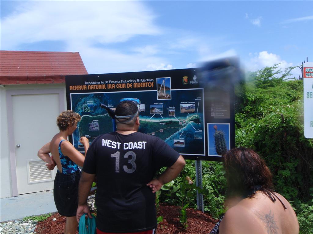
Then Alex [AlexNation] y Linsa joined us for a
daysail out to Isla
Caja de Muertos (Coffin Island). A calm anchorage was found just to the
south of the ferry docks, close enough to
snorkel ashore. Good thing, as we left Pedigo in La Guancha!
They had never been aboard a sailboat
previously, so were very interested on how it felt. After a STEEP learning
curve to adapt, they both agreed it
was very nice. The island was also a real treat; yet another park, protected by the Reserva Natural Caja de
Muertos natural reserve, because of its native turtle traffic. The government
has tastefully improved the beach and trails
to be completely attractive. The sail back to La Guancha was much easier as it
was with the wind, so Alex y
Linsa felt very sailor-like the entire way.
The next day we filled up with water from the
spigot next to the botê rampa, with permission from David & Lynn who run a
boat tour company there and had made the improvements along the shore in hopes
that the government will allow them to place a floating dock there for their
business. We shall check on them next year when we return to Puerto Rico.
Tallaboa, PR - N17° 59.187' W066°
43.000'
Our
next stop was in Bahía de Tallaboa, near the aldea of the same name. We
anchored close to the botê rampa; A location which we now seek out
because it is a good place to land and lock up Pedigo whilst we cycle
the area and the pescadoras (fishermen) are truly wonderful to converse with
and always have assistance to offer and stories to tell.
We
cycled over to Punta Cucharas for a couple geocaches near the drag strip there
(very cool) and then up to Peñuelas for a not-quite 50-mile geocache adventure, and also had one cache to get with Pedigo.
We sailed up to the noreste corner of this deep
bahía to find a geocache that we swam to, as Pedigo was disassembled for
sailing in all conditions. We anchored just above the tanks at Punta Pepillo.
It was a short swim, but a fairly long climb without shoes!
After finding the cache, we sailed across the
top of the bahía to the shore of Playa de Guayanilla,
a true pescadoras' aldea, with the
nickname of "La Villa de los Pescadores"!. We anchored between the
Rio Guayanilla and the long dock sticking out into el norte tipo de la bahía.
Although we did not go ashore, this pleasant
place will definitely be on our must-see list during our next visit. As I would
be interested in seeing the aldea from which Agüeybaná ruled the region.
San Jacinto, PR - N17° 56.883' W066°
52.771' & N17° 56.914' W066° 52.414'
Sailing
over to Punta Jacinto, we stayed on both sides of the barrio of San Jacinto.
Anchoring anywhere inside the extensive reefs and Cayos de Caña Gorda is easy,
just find the proper depth of water and a sandy bottom. We tended to stay out
in the wind to keep the bugs at bay and generate electricity.
Our
first exploration was a Pedigo
voyage to Cayo Aurora, also known as Gilligan's Island because of its
resemblance to that TV show's setting. The cache on the island was fun and the
island is yet another beautifully run government park. Is there no end to the
fabulous infrastructure the Puerto Ricans have developed in harmony with their
environment? And the outstanding thing is that access to every one of these
meticulously treated spaces is absolutely free!
Then
we cycled into Guánica and sought several very difficult caches there. One
was at a fort up such a steep and rugged path there was no chance of even
mountain biking there. Another required a ride up an 800-foot climb. Yet
another was out along a costa so desolate, I picked up thorns that caused THREE
flat tires on the way. I walked the final 2000 feet to avoid fixing any more
flats!
These travels took us past several unique
beaches and reef areas that were identified by government-produced signage;
also we went through the Guánica Dry Forest,
another completely unique and protected park area of Puerto Rico designated a
"World Biosphere Reserve" by the United Nations, featuring trees over
1000-years-old, including the rare lignum vitae.
Karin
had fallen in love with this traditional
fishing town, so we returned to thoroughly explore the area, replace the
broken first-stage of Surveyor
Alex's multi-cache here, get some more cycling miles in, and take Milton, Gladys & Natalia out for a serene
daysail on Karin's birthday.
How
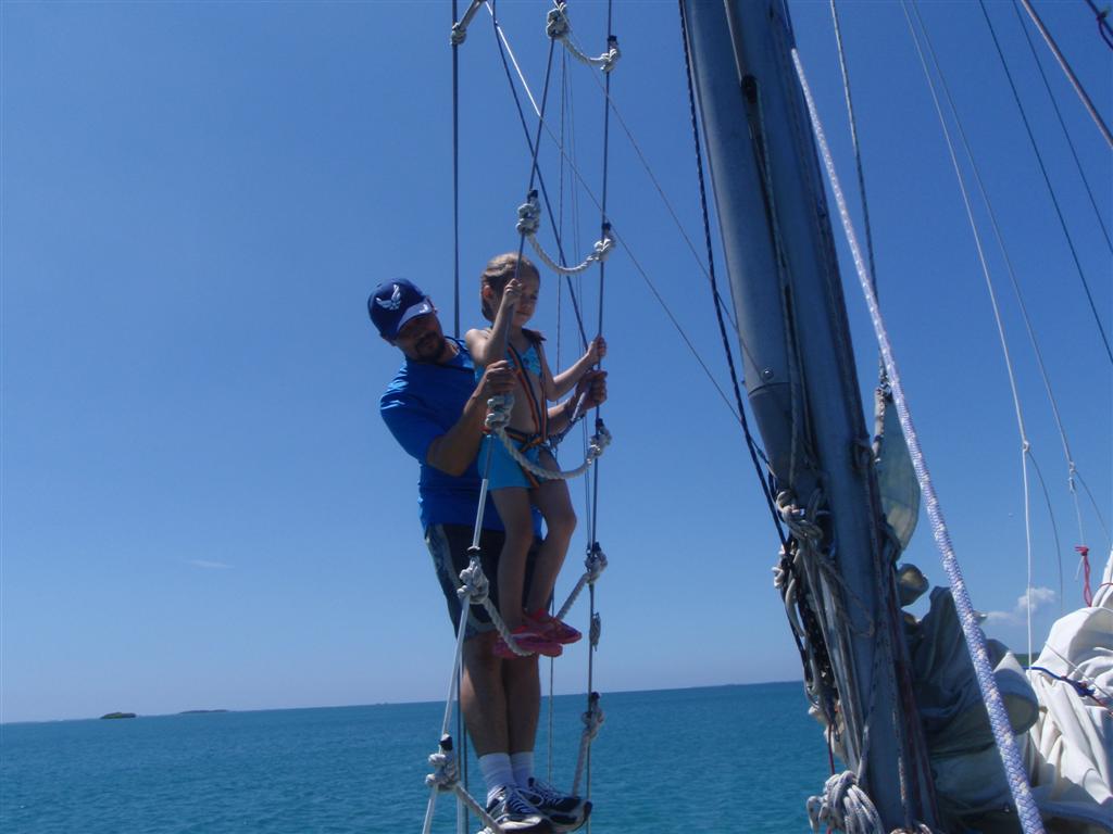
much fun can five people have on a little sailboat on one day? Just have a birthday party with balloons and food and a
beautiful little girl that had never been sailing before. We sailed through
reefs and cayos and into the tranquil Bahía Montalva enjoying Natalia's reaction to every stimulus. We anchored
and had lunch and watched nature across the water and ashore. The return sail was easier as we headed
downwind, so we were able to take a different path and explore the costas of
even more isletas and cayos, and explore all the fun stuff on Windigo, too.
We spent another week in La
Parguera, enjoying every minute. The brightest highlight for me was
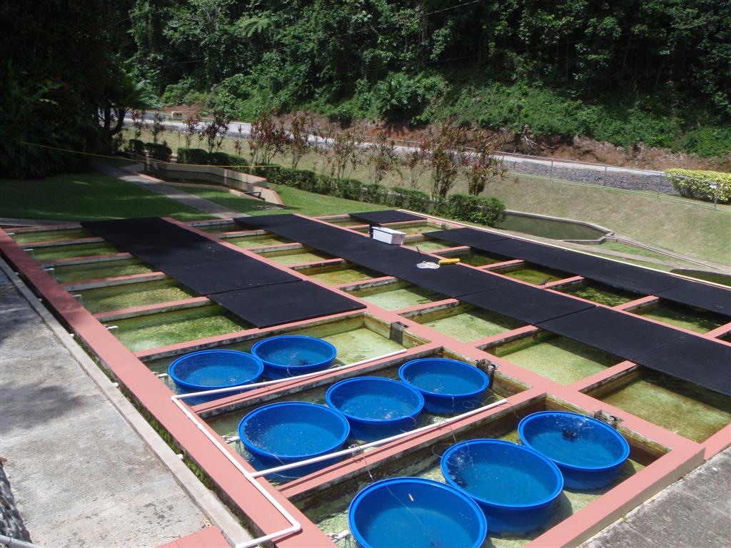
spending a day at work with Milton at the freshwater
fishery where he does research and manages
projects to restore the vitality of inland lakes by discovering methods of
raising the population numbers of species of fishes necessary for the
sustaining of the livelihood and food production for many local families. We
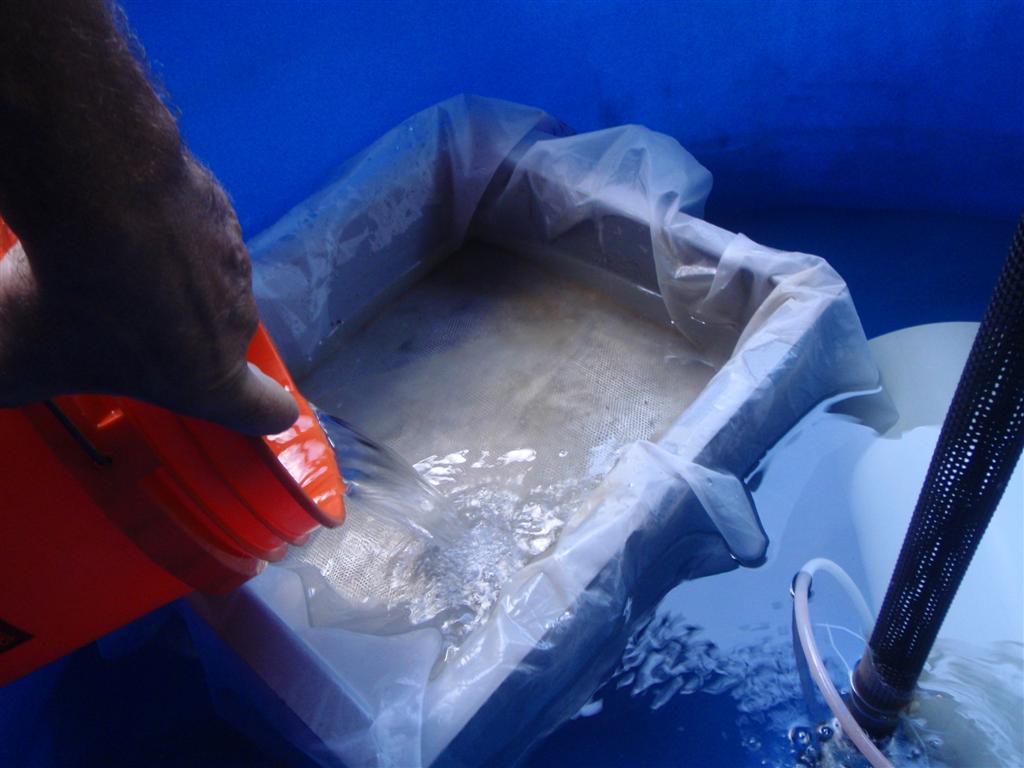
counted small fry in a tank - and I mean SMALL. At first I saw not a single
fish in the water sample
Milton collected, and he was doubting the success of the experiment. But
then he instructed me to repeatedly pour five-gallon buckets of the
water through a cheese cloth strainer. Repeatedly. Again and again. I
thought he was pulling my leg for a while, but soon [in a half-hour ;-] even I
was seeing the tiny fishys in the samples. After a LONG time (just kidding,
Milton) he was able to extract and confine, in smaller graduated cylinders,
7000 small fry! Wow. This was something that is rare to accomplish without
forcing the spawning with chemicals and such; but he had done it naturally, using
only temperature variations to encourage spawning.
[Not
to be outdone, Karin caught a fish the
very next day -- IN THE ANCHOR CHAIN OF WINDIGO!]
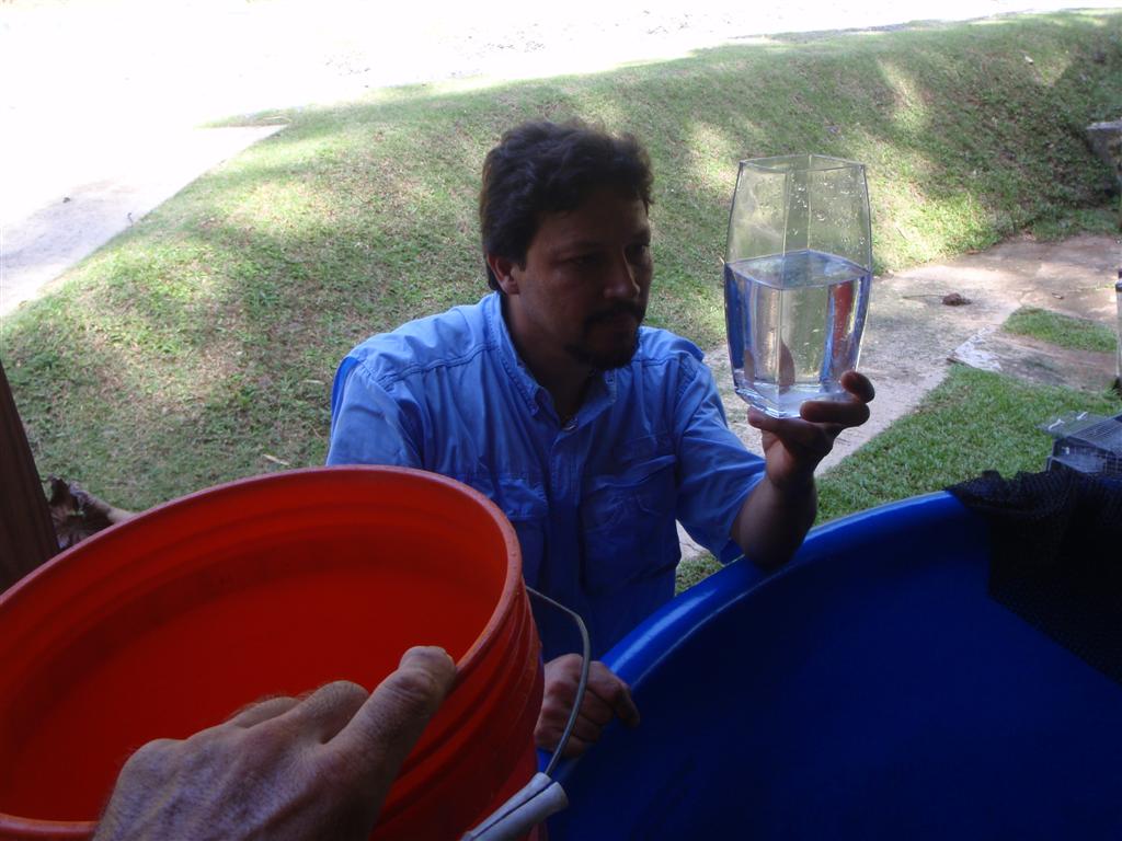
[I
also got a chance to view one of these fish under a 'modern' microscope, with
an LCD screen and a memory-capture function. I have only used the old-timey
direct optical microscopes, so I was impressed with the magnification and
clarity of these new type instruments. I could identify some of the internal
organs of the hours-old fish and see its heartbeat and circulatory system
functioning. Very cool.]
Milton
stopped on the trip back to Windigo to show me Maricao and to see the incredible monument in town [and seek another
one of his geocaches there]. The story
of how Maricao got its name is fascinating; In a nutshell, Mari was an Indian
girl who was impregnated by an early conquistador, and to save face for
the entire aldea, agreed to be
sacrificed. Wow. The whole town is a memorial to her.
I had
some repairs to do for Pedigo that required use of my welder; so I
needed access to a small space and a 120-volt outlet ashore. I introduced
myself to Hernandez at the Asociación de
Pescadores de La Parguera and after getting to know him and some of the
fishermen at the Club, I inquired as to the availability of their facilities to
meet my needs. He first suggested I set up shop in the middle of the clubhouse,
but I flatly refused to imposed so drastically; instead I found an adequate space in little
wooded area next to the fish-cleaning hut.
I
would have struggled to do the prep work on the aluminum with the huge grinder
I have aboard Windigo, so I needed to buy a small high-speed grinder,
but wondered if the tiny hardware stores in town would be the best place to get
one. I asked Milton, and not satisfied at just suggesting where I could cycle
to find one, he drove down to La Parguera early in the morning, and after we
dropped Natalia at school we went grinder shopping (and found a terrific tool
at an excellent value!).
The
fishermen were intrigued with my aluminum TIG welding, and frequently came by
to check on my progress. It was a long day of intense preparation and welding,
but with Karin's assistance we saw dusk fall on greatly improved Pedigo
seats, which should certainly last another 10 years.
It was
time to end our stay here, as Karin was shopping for a lot to build a house on! I am NOT ready to give up my
life aboard any time soon . . .
Sailing
upwind is easiest accomplished early in the morning, and it is good to anchor
before noon as the wind increases every hour beginning at about 9 or 10
o'clock. Anchoring can be made anywhere above the island, as the continuous
reef affords protection to the whole area.
"Gilligan's
Island" (sometimes reffered to as "Guilligan Island" by the
locals) is yet another place managed by the Departmento de Recursos Naturales y
Ambientales. The island is part of the Biosphere Reserve of Guánica. Just so
these guys know that their prolific work is so effective and appreciated, I
thanked them EVERYTIME I came to one of their places or if I saw them in town
[they probably thought I was a stalker!].
I just love the
idea of an entire country of peoples dedicated to preserving AND using their
natural resource that basically consists of beauty. This comes naturally* to
people with a Hispanic heart. [* pun intended.]
It was
comfortable to reach the ideal protection of Cayo Aurora this day; and as we
had thoroughly explored the whole area before, we stayed aboard and did a
couple boat projects and read, and had a nice afternoon nap. This routine was
executed so successfully that we endeavor to do it every single day we can! ;-]
We
anchored close al norte end of the island. A sandy bottom and quiet day made
this stop routine; I was glad to find a different island to hide behind in
Bahía de Tallaboa.
This area was also
exhaustively investigated on a previous visit so after a little exploration shore . . . time
for another nice afternoon nap ;-]
[I
have to laugh at the following entry I found on an Italian website:
"Some
information about Cayo Caribe
Cayo Caribe is a
place of kind Island belonging to the County of Penuelas.
The closest
populated place is that of Tallaboa that is 2.06 miles far from Cayo Caribe.
Cayo Caribe is also
1,000,000.00 miles far from the closest airport or heliport . . . "
That just about
sums it up!]
We
were busy on the one-day stop here, what with a provisioning run to WalMart
(who knows when we will see a WalMart again?) and topping off our water tank
from David Mansfield's water spigot.
Seeing
we already were the FTF on the geocache here, we had nothing to do except enjoy
the wind through the generator and take that afternoon nap.
You
will never believe what Karin found on the shore at the fisherman's landing . .
. my cycling shoes left there over THREE WEEKS ago! So you might complain about
ignored litter here and there on the island, but you certainly won't have a
theft problem here!
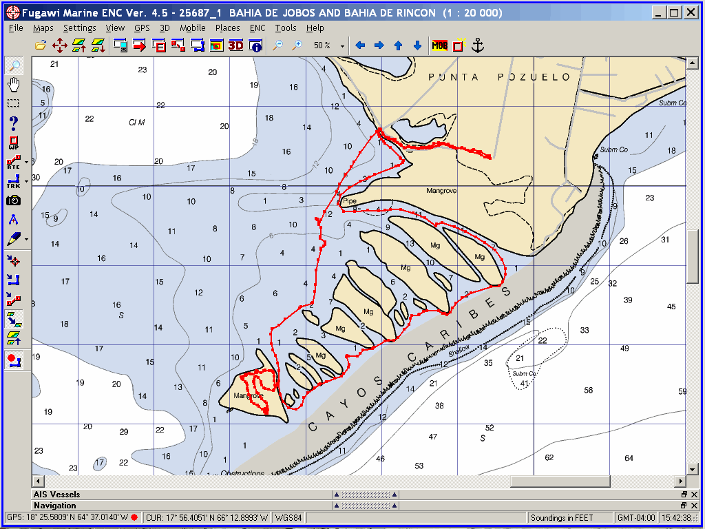
We
FINALLY ventured al este de Salinas and into the Bahía
de Jobos. This unique area
(officially called, "Reserva Nacional de Investigación Estuarina de Bahía
de Jobos") is managed by our geocaching friend Angel Dieppa, and we were
excited to finally get in here and poke around. It is mostly a water-based preserve, so we felt in the
thick of it on Pedigo. We anchored way into the string of islands called
Cayos de Caribes, and immediately got on Pedigo to really put the
repairs and improvements to the test.
One of
Dieppa's geocaches is one the very tip of the last island in the chain, so we hiked that cayo and then took
Pedigo all around the remaining 17 cayos there. Then we landed on Punta
Pozuelo, the large cay at the top of the group that is connected to the main
land. It has an old airstrip, salt ponds and hiking trails that were
fascinating. A return trip shall see us spending a great deal more time in this
area and poking about in every nook and cranny.
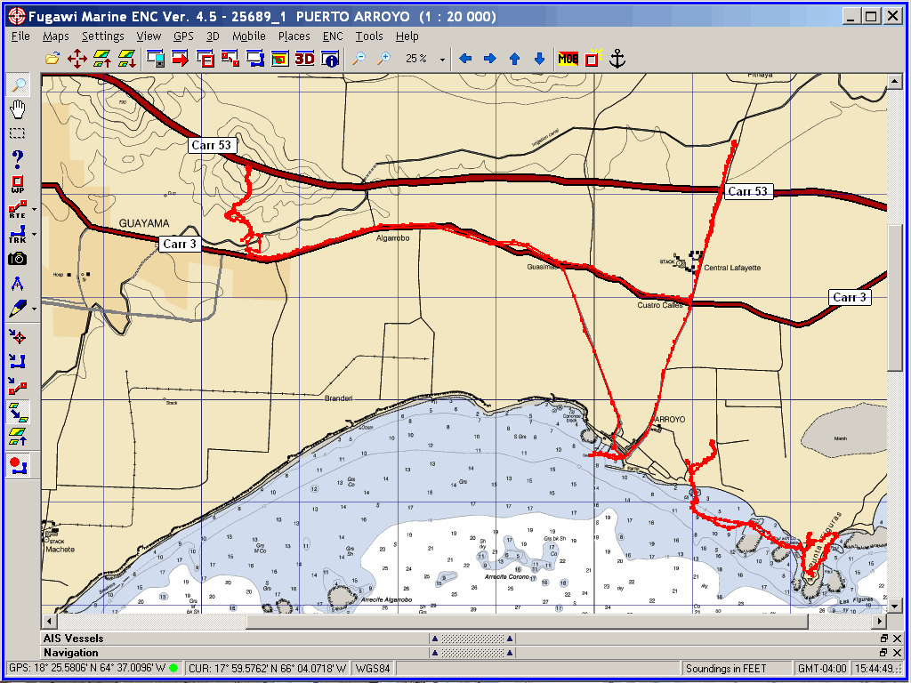
With
four geocaches in Arroyo, it was a must-stop destination (although one of the
caches was disabled). We anchored behind one of the several reefs at Punta
Figuras and took Pedigo up to the beach for a couple caches. We hiked
all through the new lighthouse park and around to the old lighthouse on the
costa.
Then
we took Pedigo up a slough 1000 feet, into town to access another cache
by hiking to a ruin just outside town. We climbed up the steep banks of the
slough and over a couple fences to get to the sugar mill ruins for the third
cache.
After
exhausting la geocaches de costa, we headed inland for some more after
relocating Windigo next to a tiny, unfinished marina in a shallow
(one-to-three feet!) harbour. Someone had good intentions, but the lack of
money or the over-abundance of bureaucracy has stalled the project.
Karin walked a couple miles to
one at the ruins of an old church, but I cycled 10 miles to get to a
mountaintop cache that I struggled to reach, and did not find. :(
As it
is with most Puerto Rican aldeas, this one has several nicknames, the most
descriptive is simply, "Pueblo Grato" (pleasant town). An interesting
tidbit of history: Sam Morse personally installed the first telegraph line of
Puerto Rico or Latin America here in 1859. Memorabilia of the event is at the
Museo Antigua Aduana; another must-see item for the turista is the Tren del Sur
de Arroyo (South Train of the Stream) [which was being renovated during our
visit].
Because
of the poor protection from swells behind the breakwall in Arroyo (we have too
deep a draft to get into the basin properly) we headed out that same day and
sailed around Punta Figuras to our next stop.
We
failed to get anchored before dark, so it was interesting to judge the position
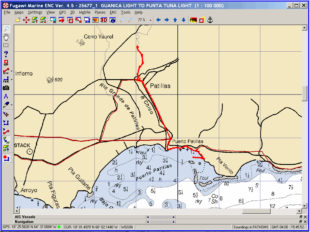
of the reef, the town dock and the shore for a peaceful anchorage. We pulled in
behind the big reef off Punte Viento and anchored. We were delighted to awake
in a decent spot just off the boté rampa, which facilitated the landing of Pedigo and the bikes.
Only
one geocache was at this stop, and it was a sufficient distance that Karin had
to unload her bike and cycle there with me. The effort was rewarded greatly:
the cache was up & up & up a road that led to the elevated Lago
Patillas (the name "patillas" refers to watermelons!), held behind a
dam to produce hydroelectricity and provide a recreational site for the area. It was a workout climbing up there,
but the gentle rain that fell the entire way keep us cool (and clean!). The
energy expended in the climb dissuaded Karin from cycling further inland (and
up MORE mountains) to get two other caches within several miles (she said,
"YOUR 'several' miles becomes MY 'dozens' of miles", and she was
mostly correct!).
Instead
we thoroughly enjoyed the fast descent to the botê rampa and got the bikes back in the rigging on Windigo for
more further sailing adventures.
There
was a single geocache at the light on Punta Tuna, but the swells were so bad
here we decided to stay aboard and come for the cache during another trip. This
would only be a decent anchorage in absolutely calm conditions. We suffered
through a night of rocking by the swells. We intend on visiting the city next
time to find out if it lives up to its name on land = "Ciudad Tranquila"
(peaceful city), because it wasn't in the water on this night!
It is
also known as "Ciudad de los Jueyeros" (crab city), so maybe we were
suppose to feel ornery?
Cayo
Santiago is known as "Monkey Island" as about a thousand free-ranging
rhesus macaques live here. Turistas are not allowed ashore as the
monkeys are quite wild and have no qualms about attacking invaders. The colony
is run and maintained by the Caribbean Primate Research Center (CPRC) and the
University of Puerto Rico, Medical Sciences Campus and have been visited for
almost 70 years by scientist from all over the world.
The
monkeys currently living on the Cayo are divided into a few natural social groups.
The individuals in the current colony are the direct descendants of 409 monkeys
who were brought to the island in 1938 from India. The monkeys are fed a diet
of Purina monkey chow from three feeding locations on the island. The
population also eats a variety of other indigenous foods, including leaves,
fruits, flowers, and soil. The monkeys have ad libitum access to drinking water
at a number of locations.
We
anchored close enough for the monkeys to notice us, and they performed a three
act play, with an introduction of players, dramatic storyline, action and
adventure in the trees, and in the finale they beg for audience participation
with taunts and gestures. We laughed so hard our sides hurt.
Another
thing in the trees were several four-foot long iguanas, pulling the leaves from
the extremities of the skinny branches. How they managed not to fall with the
slightest breeze or the tiniest misstep was a mystery, but there they were,
high up in the branches eating the most tender leaves.
There
was a geocache directly across from us on the mainland at Playa de Humacao, but
the conditions were rough enough to cause us to forego the attempt (We
experienced the worst squall of the year on the voyage over to Cayo Santiago).
We
made a stop at the end of Vieques because it was on the "sailing
path" up the costa oriental of Borinquen and we wanted to seek the only
cache on the island [there has since been a new cache placed on the costa
meridional near Ensenada Honda]. What I didn't realize is that the Departamento
De Recursos Naturales Y Ambientales has improved the costa occidental of the
island with mooring balls! And what a fantastic 'open' anchorage; even though
there was a bit of swell running across the sea, the area just below Punta
Arenas was perfectly calm. We stayed THREE DAYS!
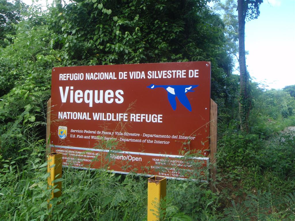
This
area is part of the Vieques
National Wildlife Refuge and is one of the finest snorkeling spots in
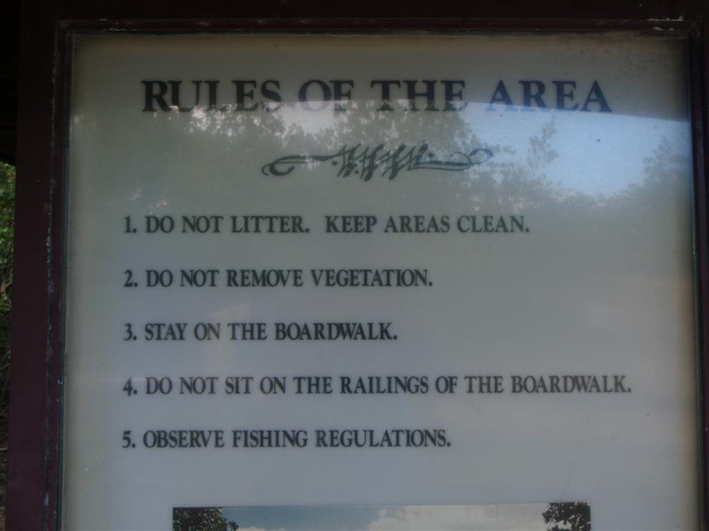
Puerto Rico. The view of the main island is superb also! The Refuge has a few rules, but you better follow them!
One
day, we swam(!) ashore and hiked through a
fairly large road-improvement project to reach the old Navy bunkers where the
geocache was hidden. The locals have found interesting ways to use the
abandoned structures here, using one for the storage of recyclable materials
for later dispensation.
The
little bit of this island that we've seen and the few people we've met, have
been totally fascinating and attractive; we will spend more time here on a
future voyage.
We
enjoyed short hops between anchorages as we were in no great hurry to leave
Puerto Rico and the Spanish Virgins, although the time to go back to work was
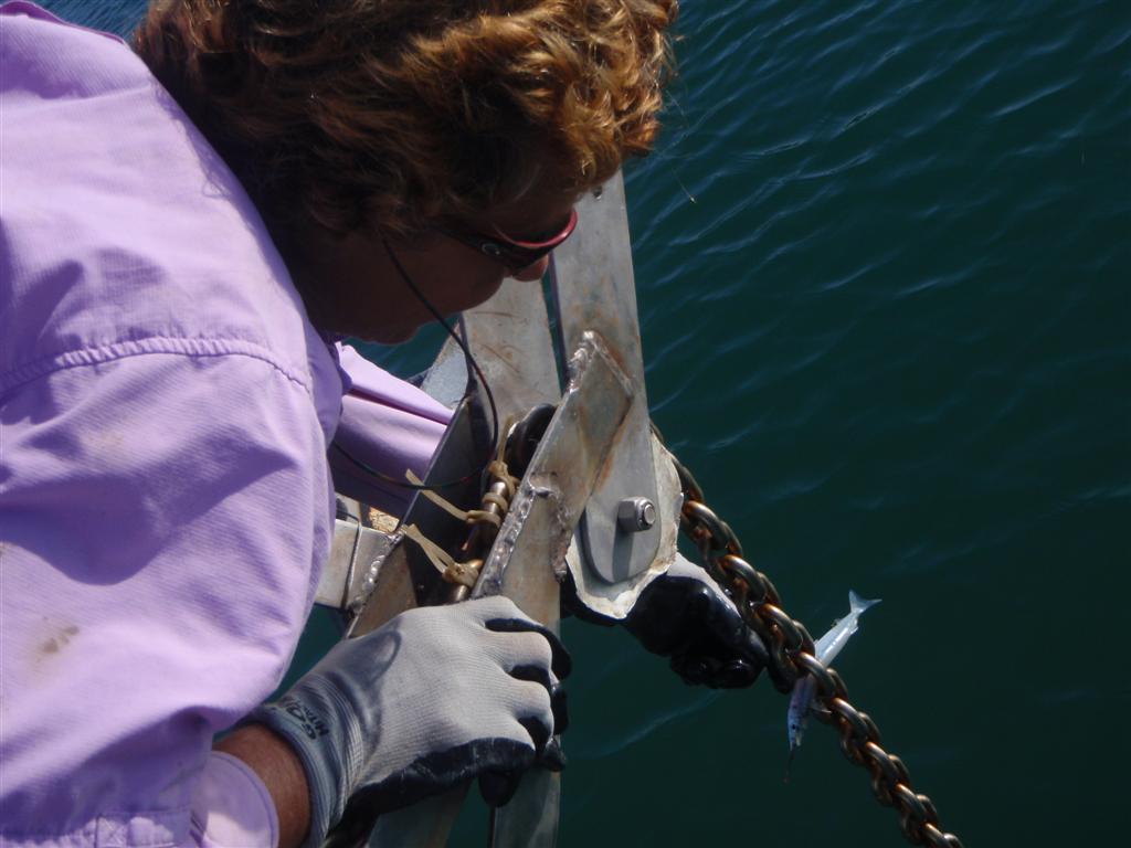
almost upon us. This stop allowed us to have another conch dinner!
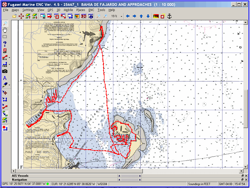
This
is the anchorage next to the largest marina in
Puerto Rico and I had stayed here in 2008. We came in to connect to the
WiFi and update emailios, but it was too rough to remain this day, and the inet
wasn't cooperating anyway; So we moved along up the costa.
Turns
out we connected to the inet here, and had lots of activities planned using
this tranquil anchorage as a base. The anchorage is next to a large marina and
condo complex on a tiny isleta, the reefs provide great protection in all kinds
of conditions. We anchored just behind a working barge that was moored in el
sur de the anchorage. [Beware of submarine cables marked on the chart!]
The
water had calmed down completely from its disturbed state of only a week ago,
so we were able to make several Pedigo excursions including the circumnavigation of Isleta Marina, and
a six-mile trip across to the mainland! We found a geocache at the resort
in Fajardo, and explored several of the marinas there. We also found a strip of
land that had over 100 iguanas on it of all shapes and sizes. Our trip was cut
short as a bit of nasty weather was seen approaching from el este, so we
scurried back across the bahía de Fajardo to the safety of Windigo.
We checked out all the reefs and the resort on
Isleta Marina, and decided to move along after a three-day stay.
With the seas so calm, we braved the reefs that
guard the entrance of Bahía Las Cabezas and anchored deep inside. After making
this entrance, I believe I could return anytime except the worst sea
conditions. The reefs are shallow, and I have seen tremendous breakers over
them while sailing along the costa septentrional in the past. But the entrance
is deep, and if the breakers are not so huge that they disrupt the water across
the whole bahía it would be easy to find again. But the seas can be
tremendously large in this area, so caution is urged . . .
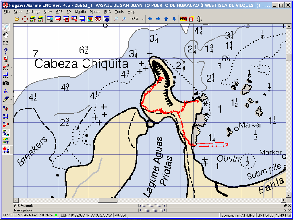
Taking Pedigo to shore, we hiked some very beautiful
trails with ancient ruins through an area with some type of protected
designation on the peninsula of Cabeza Chiquita between Bahía Las Cabezas and
Laguna Aguas Prietas. We walked part of the way with two people from the Sierra
Club. They believed that they were instrumental in getting this land protected.
As we approached the second cache, it seems we
stumbled upon a nude beach; sure enough, in the log for that cache it mentions
that landlubber Americanos might be shocked or insulted to bring little kids to
the place. How different is the attitude of people that remain isolated most of
their lives . . .
With the perfect protection of the free
moorings at Cayo Icacos only
a few miles away, we bugged out of Bahía las Cabezas and took a ball for the
night. It amuses me to recall the number of times "officials" in Ft.
Lauderdale, Gulfport, Clearwater and other places in Florida tried to justify
hassling the crew of Windigo when we were simply exercising our
international right-of-navigation; but elsewhere in the world, power and greed
are not the only things that matter. Forming governmental agencies simply to
improve the quality of life is an old tradition, but I observe it being mostly
lost in the mainland of America these days.
We came into Bahía Flamenco to seek a geocache;
we didn't find the cache, but instead we found an incredible anchorage behind
shallow reefs similar to Bahía Las Cabezas. I wouldn't want to be in here in
rough weather, but on a calm day it is glorious. The entrance is again between
shallow reefs, but easy to negotiate in fair weather.
Turns out this beautiful beach is rated one of
the BEST IN THE WORLD! Who'd have guessed? After swimming to shore and
exhausting our efforts to find the cache, we returned to Windigo for the
night; We felt the seas increase as the night progressed, so we beat it outta
there early in the morning.
[We returned here on foot from
the next anchorage to search through a huge pile of cleared brush that remained
during the road improvement which was in progress. It seems the construction
has destroyed the cache. But more interesting was the sea condition on the
beach that we swam to on the previous day. There were two-meter seas (6-foot!)
crashing on the exact spot we walked up on the beach - no way could we have
survived that landing!]
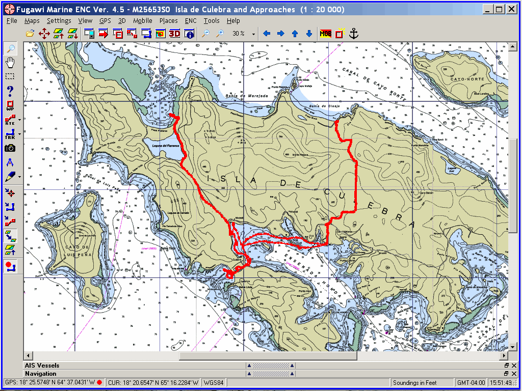
We ventured deep into Ensenada Honda (yes,
another Ensenada Honda on a THIRD adjacent island . . . a topotomists
nightmare!) on Isla de Culebra and anchored behind Cayo Pirata. We spent a
couple days here checking out the towns of Dewey and Culebra, making two six-mile
hikes (IN THE SAME DAY!) to Bahía Flamenco and Bahía de Oleaje to seek
geocaches. A great anchorage with US services (phone, Post Office, etc.) it
seems a delightful place to hang out for an extended period - perhaps in the
future.
We met a few locals, didn't find either
geocache, got sprayed by the vector-control truck (we got NO mosquitoes now!),
made a couple long Pedigo journeys of exploration, and generally spoke our last
Espanol to anyone who cared to hear their language beaten up a bit.
The
night before we were to depart, we moved out near the entrance of the bahía so
we could see the weather, sea conditions and be over a mile closer to our next
island, which would NOT be in the Spanish Virgins. This is the last full bahía
inside Ensenada Honda, but many boats anchor around on the outside of Punta
Colorada behind the reef above Ensenada Dakity. That seems like an really neat
place to stay, with a full view of the ocean spread out in front of the
anchorage. Next time we shall . . .
This
would be our last anchorage in a Hispanic country for some time, and we will
truly miss it; But we need to refill the coffers, as the few pennies left in
the bottom rattle around and make a lot of noise as we sail around.
AND NOW, THE
SECTION WITH "FEELINGS" - VIEWS FROM THE FEMALE CREW:
Girlie Stuff
When
I had left Windigo in 2008, we were anchored in the San Antonio channel
by Old San Juan. When I returned to Windigo, we instantly sailed over to
Old San Juan and anchored in the San Antonio channel once again. I have to say
that my feelings were mixed and I felt very uneasy there. I knew that we were
there for one reason only and that was to get "my stuff" that I had
mailed there and we were going to reprovision the boat. I commented to Kevin
that I wanted to leave this island as soon as possible and head over to the
BVI. When we had finished up our business and it was time to go, I realized
that we were getting into the most unpredictable time of hurricane season.
Kevin pointed out that there were some really great hurricane holes on the
southern part of Puerto Rico and we should check them out. I agreed with him,
but not wholeheartedly.
He
did an excellent job of planning our route so that we could stop for a day here
and there, do some geocaching along the way, basically anything that he could
think of to satisfy my apprehensions but still satisfy his desires to
circumnavigate the island. We both wanted this to be time of reconnecting on Windigo
within the lifestyle that we both love.
Just
to sum up the adventure is to say that I wouldn't have experienced Puerto Rico
any other way! Some of the high points (there are way too many to list) were;
meeting other geocachers and participating in my first geocaching event,
sailing with new friends, continually learning how to speak better Spanish,
anchoring in many protected harbors and walking/riding bikes in nearby towns.
But more importantly to me was meeting the local Hispanic people who were so
beautiful; both inside and out.
Now,
after 64 or so different anchorages, even though it was very hard to choose, I
do have one special place that I
would pick to live the rest of my life out at. This was the little town of La
Parquera (pronounced: la-par-goo-airrr-a). Don't forget to roll your
"R's" as I was constantly being reminded.
I'll
just sum this up by telling you why this place, over all the rest, really
captured my heart. There were about 30 different mangrove cays and islands in
this small area so during our daily Pedigo rides we never had to go the same
way twice. The water was the clearest I had seen in a while and there was
enough wind to keep our batteries charged up without any of the rolly/swelly
seas (comfort factors). The people were so nice that even though there was more
of a language barrier than usual I was still able to find the library, laundry,
book exchange and anything else I needed. I celebrated by birthday with a great
day of sailing with new friends Milton, Gladys and Natalia. Then, my
ever-so-thrifty husband took me out for dinner at a place that served the best
fish around. The bottom line is that I felt welcome, safe, comfortable and
happy - what more is there! Now I have to figure out exactly where I want to
build that house . . . hmmmm.
Beaches
I was
just noticing that this eLetter wasn't long enough . . . since we traveled the
entire country's costa, I thought I would include this list of BEACHES:
Puerto Rico has 272 miles of costa, and plenty
of beaches to go around it. To contrast, there are places with water as calm as
a pond and fantastic breakers with world class surf. Beaches here may be lined
with high-rise condos and hotels, or in pristine national wildlife refuges.
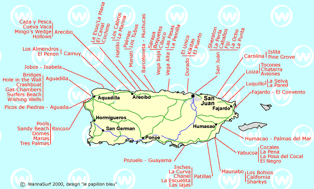
MOST FAMOUS BEACHES AND BEACH AREAS
Condado = hotels
Isla Verde = more hotels
Pinones = parks and shoreside local cusine
Luquillo = en el este de la costa septentrional, resorts and
waves
Isla Palominos = snorkel park, moorings, beach
Flamenco, Culebra = gorgeous bay, great beach, wave action
Isla Vieques = relaxed atmosphere, local flavor
Guanica = quiet, local flavor
Cabo Rojo = local weekend migration spot, several beaches
Rincon = SW tip of main island, center of surf beach
activity
Aguadilla = in the surfing beach area, but with a local
flavor
Shacks Beach = Isabela surfing beach
Jobos Beach = Isabela surfing beach
Montones Beach = another surfing beach near Isabela
Guajataca Beach = yet another Isabela surfing beach
COMPLETE
LIST OF THE 71 PUERTO RICAN SURFING BEACHES
![The Trip. [MAP]](THE%20Circumnavigation%20of%20Puerto%20Rico.gif)
![Bahía Demajagua [Puerto Del Rey], PR](Bahia%20Demajagua.gif)